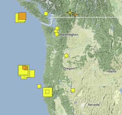

With the recent Eureka, California, earthquake registering 5.6 (not that serious, compared to their 6.5 in 2010) and the 6.0 roughly 160 miles out to sea from Coos Bay, Oregon, it seemed a good time to visit the Pacific Northwest Seismic Network to what the big picture showed regarding our squeaky Juan de Fuca plate.
But what were those little stars up near the Washington-British Columbia border? I checked the map’s key. “Explosions”?
Curious, I started clicking around to see if we were under unannounced invasion, and discovered PNSN was already on it, with a blog post on British Columbia coal mine blasts.
As grad student Alicia Hotovec explains:
Turns out the signal most likely originated in southeastern British Columbia, somewhere near Elkford. I Googled the area, and there are several sizable coal mines nearby. One of the techniques used to efficiently extract material from mines is something called ripple-fire blasting. Charges are set off with short but consistent time delays, usually around a tenth of a second apart.
That delay generated a peculiar harmonic signal “heard” at various volcanic seismology sites. The size of this blast is “not unprecedented,” according to the UW’s Steve Malone, who has had his ear to the Northwest ground for longer than most.
Still, if we’re eventually overrun by Canadians emerging from secret underground tunnels beneath the border, don’t act so surprised.