All posts by Arne Christensen

The Great Washington ShakeOut, an Earthquake Drill, Set for Thursday Morning

In Part 2 of this series (Part 1 here), The SunBreak’s Northwest Earthquake Correspondent Arne Christensen checks in with John Schelling (@jdschelling) of the Washington Emergency Management Division about earthquake preparation, in advance of the state’s ShakeOut preparedness drill on October 18th.

Arne has also written a previous series on earthquake preparedness in the tech sector, and the psychology of readiness. He also maintains this Nisqually Quake site, which collects stories on the subject. 
The ShakeOut, the largest-ever earthquake drill in Washington, is coming up on October 18th. I’m sure a lot of schools have signed up for it, but is it hard to get adults to participate in these sorts of drills? Do you hope that kids will recruit their parents into preparedness after doing a ShakeOut at school?

One of the central tenets of the ShakeOut is to get families, friends, and neighbors to talk about what they did at school, home, work, etc., during the ShakeOut earthquake and tsunami drill. This helps foster conversations about preparedness and reinforces the need to get drop, cover, and hold into our muscle memory–and running to high ground after the shaking stops if you’re near the water.

So, if kids come home from school and talk about what they did at school today and parents talk about what they did–and they both participated in the ShakeOut–it can lead a great discussion about how well the family is prepared, and encourages them to follow through on anything they still need to do to. If you haven’t registered to be part of the largest earthquake drill in history, The Great Washington ShakeOut, it’s not too late to sign up.

There’s no doubt that getting kids to participate in school is easier, but that in and of itself is so vitally important for a couple of reasons. First, it will promote the discussion that I mentioned previously and may encourage parents to support participation in the workplace during future drills. Second, it leads children to become better prepared adults and promoting earthquake safety within their own families.

As for [workplaces] looking at the drill as a distraction, the drill itself takes less than a minute to run through using the 57-second recording we have provided. Companies can play the drill notice over their PA systems and have people practice Drop, Cover, and Hold under their desk. A two-minute or less disruption to daily business operations is a good investment in keeping a company’s human capital safe.

We have big and small businesses alike signed up for the ShakeOut this year, and our goal will be to continue to promote earthquake safety and encourage participation to the greatest degree possible. My goal is to double participation in our businesses community during next year’s drill.

I’m sure social media (the ShakeOut is on Twitter!) and smart phones have really changed the way you do disaster education. What are the major advantages of the new technology? And are there any significant problems created by it?

Social media and the creation of smart phone apps have opened up so many new opportunities to engage people in disaster preparedness. It allows public educators to help spread the word to people and groups much more directly and much more quickly. It also allows users to only receive the information of interest to them.

What we have seen is that when misinformation is initially spread within the user community, other users quickly step in to make corrections. Social media has also empowered people within their communities to connect virtually and create neighborhood preparedness groups online through Facebook and other social sites. A great example of this grassroots effort in Pacific County is Eye of the Storm. This group originated through Facebook and is now organizing annual preparedness fairs to promote earthquake and tsunami preparedness within their community!

As for drawbacks, I think it’s important for preparedness educators and emergency management organizations to recognize that the digital divide still exists and not everyone has a smart phone or uses mobile applications. There are people out there who don’t own a computer or use the Internet, and we still have many places throughout Washington State that don’t have cellular or mobile data coverage, so it’s essential that we continue to reach out to everyone–regardless of their expertise with or access to technology.

In addition, it can sometimes be challenging to provide a response to user communities that operate on a 24/7 basis with employees that are scheduled to work from 8 to 5. However, these are not new issues and are to be expected with any new technology. I’m confident that individuals and organizations will adapt to meet these needs.
Prepared for an Earthquake? It’s Disaster Preparedness Month.

In Part 1 of this series, The SunBreak’s Northwest Earthquake Correspondent Arne Christensen checks in with John Schelling (@jdschelling) of the Washington Emergency Management Division about earthquake preparation, in advance of the state’s ShakeOut preparedness drill on October 18th. Arne has also written a previous series on earthquake preparedness in the tech sector, and the psychology of readiness. He also maintains this Nisqually Quake site, which collects stories on the subject. 

Still from the movie 2012 (Columbia Pictures)

Aside from “drop, cover, and hold on,” what’s the most important thing people can do to prepare for earthquakes?

Anything! If people can do at least one more thing to become better prepared for an earthquake, they will definitely be prepared for the disasters that occur more frequently in Washington. Personally, I recommend everyone have a plan! It doesn’t have to be something long and complex…a piece of paper or two will work just fine.

Your plan should include some basic details, such as phone numbers for out-of-area contacts (best to have more than one in case your first choice isn’t home!), and depending upon your situation it should include numbers for schools, daycares, adult family homes, primary care doctors, and numbers for vets and locations of pet-friendly hotels if you have loved ones with four legs.

Your plan should identify specifically where you will meet your family in your neighborhood, as well as places that you would meet in case your home and neighborhood are inaccessible. Our family meeting place inside our neighborhood is at a park next to our house, in case we have a fire or have to evacuate separately. Outside of our neighborhood, we plan to meet at my wife’s office. You should contact your local emergency management office or Red Cross Chapter to determine locations of shelters in your area and have a primary and secondary choice. You may also want to include phone numbers for the shelters in your plan.

Can you see the theme here? Yep, it’s redundancy. It is best to have a primary and a secondary choice for each part of your emergency plan since we cannot rely on just a single point of contact, rendezvous point, etc. Also, make sure all of your family members have a copy in a waterproof container, like a ziplock baggie, that they can keep in a backpack, car, school, office, and home.

What people, families, neighborhoods, communities, do today to prepare will determine how quickly they recover from our next disaster. It will also give them peace of mind knowing that they have done everything they can to help themselves and their families. Building and exercising a plan allows a person to spring into action rather than by crippled by fear or panic when faced with an otherwise frightening situation.

4.0 or greater Northwest quakes from 1970 to 2010 (Chart: Arne Christensen)

Do you think people should try to make themselves more mindful of disaster threats on a day-by-day basis (such as noting the Northwest’s many small earthquakes), to educate and train themselves for when a disaster does happen? Or would that simply create a lot of useless worry?

Since Washington generally experiences on average four or so earthquakes per day, I wouldn’t suggest that people try and keep track of them or needlessly worry. However, I would highly recommend over the course of one year Pacific Northwesterners do at least one activity per month to help themselves and their families become better prepared.

We’ve developed an easy to follow program called “Prepare in a Year,” which is designed to help people get ready over a 12-month period by dedicating just one hour per month to emergency preparedness.

Already prepared? Well…now it’s time to think global and act local. Okay, maybe not global, but at least think about your neighbors! If you haven’t met them before an earthquake, I can almost guarantee that you’ll meet them afterwards. So, why not start working together to get your street, your cul-de-sac, the floor in your apartment building, ready beforehand?

Wouldn’t it be great to know by name exactly who you could turn to in your neighborhood for a skill or a resource in an emergency? Think about how reassuring it would be to know that your neighbors two doors down have CPR training, or that your neighbor across the street is a licensed amateur radio operator and can communicate directly with responders when phones are down?

To help make neighborhood and community preparedness easier, we’ve created an award-winning program called Map Your Neighborhood, which builds on the age-old concept that neighbors can help neighbors respond and recover from the events that Mother Nature throws our way. You can check out our website and then contact your local emergency management office to get involved.

I also suggest that when you feel a smaller earthquake or hear about something happening halfway around the world, like the Japan earthquake and tsunami, pause–for just a minute–and really assess what you have done to date. Would you have been ready? If not, take that first step: I promise you’ll feel so much better after you do! There’s no need to worry if you take steps ahead of time to prepare your family, your home, and your workplace for the unexpected.

What Lies Beneath? The Defunding of GeoMapNW

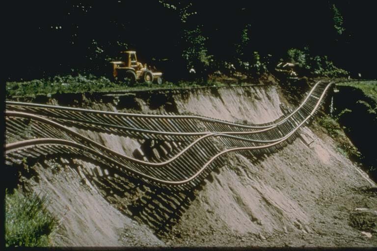
Union Pacific Railway Damage from Ground Deformation, Seattle, Washington Earthquake of April 29, 1965, Seattle, Washington. (Photo: University of California, Berkeley)

I met with Kathy Troost, the director of GeoMapNW, in spring 2010, at a time when the effort she led was struggling to remain operational because of cuts in state and local funding. The Washington state budget, and everyone else’s, has gotten even tighter over the past two years, and Troost’s search for new public and private sources of funds did not manage to keep GeoMapNW going into 2011.

I intended to write an article describing GeoMapNW’s funding needs that would perhaps help the geological mapping continue by encouraging a few people and/or groups to contribute some money. This much-delayed article is too late to do that, but I hope it will let people in Puget Sound know about GeoMapNW’s achievements and what the project has told us about the seismic and mudslide/landslide threats the region faces.

The information produced by the effort remains available and as a Subsurface Geology Information System, covering much of the area from Mukilteo south to Federal Way, and from Kitsap Peninsula east to Fall City. GeoMap NW is also still available to perform “high-resolution geological mapping services and database services” to select clients, as stated on their website, but new mapping for general public use is no longer being done.

Even in spring 2010 it was ironic that GeoMapNW was struggling to keep going at a time when massive earthquakes in Haiti, Chile, and China had shown how important it is for the Northwest to address the region’s seismic threat. And then, on March 11, came an even greater display of the value of an updated, detailed geological map of the region, with the Japanese earthquake and tsunami.

The irony would be easier to take if the stakes weren’t so high: The central Puget Lowland, the target of GeoMapNW’s efforts, faces not just the threat of a subduction zone quake and tsunami but the threat of an inland quake similar to those of 2001, 1965, and 1949, as well as a Seattle Fault quake that could devastate cities around Lake Washington.

Troost explained that she was using information from boreholes drilled deep into the soil—each one takes three hours to complete—to develop data sets describing the soil types for various parts of the area, which is “a very complicated geologic setting,” as she said. The mapping process also used Lidar, which sends laser streams down through the soil to detect the density and moisture of its varied layers, to obtain a much more precise and deeper set of data about the earth we live upon. Polygons drawn on a map classified these various soil types and provided data about each section defined by the polygon.

Before GeoMapNW began, the last soil maps for Seattle had been done in 1962: most of Interbay, downtown, and Sodo was a blank on those maps, even though those areas have just about the most unstable soils in the city. The value of the new mapping lies in both covering that unknown ground and in its establishment of finely detailed maps of areas that had been only roughly sketched by the earlier mapping projects.

GeoMapNW also revealed several valuable surprises: Loose, unstable soil exists not just along the shorelines of Puget Sound and filled-in areas like Harbor Island and SoDo, but also on hills, at the tops of hills, and in the middle of West Seattle. You may think that your home or office is on firm ground because it isn’t near water, but this isn’t necessarily so. The many layers of sediment laid down around Seattle by glaciers, volcanic flows, and erosion may have established seemingly firm ground, but they do not constitute bedrock.

The new maps done by GeoMapNW required about 300 soil borings for each square mile: this meant that, in a sense, it was not inexpensive work, taking 900 hours to map just one square mile of sprawling urbanity. It cost $500,000 to operate GeoMapNW for one year. But, the knowledge furnished by GeoMapNW gives soil engineers and architects the ability to make preliminary plans for how to prepare a site for the construction of a building, and for infrastructure projects such as roads, sewer lines, and rail tunnels. By looking at the new maps, they get a clear sense of what the building site is like before going to the site, surveying it, and beginning construction.

Obviously, it’s hard to calculate the value of using the GeoMapNW data to put up buildings that do not tumble down in an earthquake or mudslide. But, we can guess at the cost of replacing just a couple of buildings destroyed by a disaster because they were designed without using new data on soils, as well as the casualties suffered by those building failures. Comparing that avoided cost to the salaries paid to some of Seattle’s most expensive and least productive sports stars, or to some of the compensation packages handed out to executives at WaMu, is a pretty bad joke.

The halt to the GeoMapNW project is an example of the long-term harm that can come from bad budgeting, which governments are just as susceptible to as households and businesses. It’s not at all hard to envision Troost and other geologists and engineers saying, after the next bad earthquake, that “if we had kept our mapping going, we would have been able to avoid this building collapse, those deaths, this bridge collapse.” Indeed, Troost told me, “The government agencies are shooting themselves in the foot by not funding this project. It would cost them more work and trouble if it ends.”

The cities that had the most extensive mapping of their soils done by GeoMapNW include Seattle, Redmond, Bainbridge Island, Bellevue, Kirkland, and Mercer Island: the wealthier parts of the Puget Sound, the areas that are best able to deal with and recover from an earthquake. You get the sense that mapping is a luxurious kind of risk management: while other towns are struggling to plan for ways to deal with casualties and repair broken infrastructure because they simply lack the funds to do retrofitting or exhaustive analysis of building sites, Bellevue, Redmond, and other towns have the tax base to fund such investments.

This is something Carol Dunn of Bellevue’s Office of Emergency Management pointed out to me: the best prepared areas are usually those that have the most resources and have the most to lose, financially speaking, from natural disasters. These aren’t necessarily the same areas that are most vulnerable to a natural disaster.

Troost was “always giving away maps” even while struggling to keep her project going; she was considering putting in a subscriber-based database by July 2010 to provide a new funding source for the project. It didn’t happen, but this struck me as a good idea: it seemed completely ridiculous for anyone to think that the information GeoMapNW provided was or should be free. After all, private geotechnical and soil surveying firms don’t give away their work, and it was entirely reasonable for those firms to help cover the funding crunch by contributing to the maintenance of a resource that helped them do their work.

GeoMapNW was not recklessly burning through its funding: The GeoMapNW headquarters were located in the old University of Washington oceanography building, in a very quiet and neglected area behind the UW hospital, near a dock on Portage Bay. It was not a high-overhead operation, and most of its work was being done by grad students.

In spring 2010, Troost said the impending end of GeoMapNW was revealed around the turn of 2010, when local agencies apparently realized quite suddenly that they had to cut their budget for the upcoming year because they were simply running out of funds for discretionary projects like GeoMapNW.

They told her, in effect, “Sorry, we don’t want to do this, but we have to cut our funding to you.” Two years later, the result of all those cuts is the discontinuation of the mapping project and its existence as a static, limited, free resource. So if you’re living or working in Tacoma or Puyallup or Everett, you can still go to the GeoMapNW site, but you won’t get any new information about your soils: the project didn’t get to your area before the funding ran out.

Cascadia’s Fault Tells How Scientists Uncovered the Cascadia Subduction Zone

The jacket copy for Cascadia’s Fault touts it as a disaster book, one that prophesies doom for the Northwest and comes with the warning that an earthquake like the recent one in Japan “could happen tonight.” The copy also appears to be capitalizing on the Chile and Japan subduction zone earthquakes of the last two years, to try to panic the reader into buying the book.

A foreword by Simon Winchester expands on this idea by claiming that recent earthquakes on the Pacific Rim have furnished the trigger for an impending doomsday quake off the coast. But after the rush of stories over the past three months about the threat of a subduction zone earthquake and tsunami, you probably already know that it can happen here. The question for the browser is: Why do I need to read an entire book about the subduction zone?

Well, Jerry Thompson has produced a book that’s not really all that alarmist: In Cascadia’s Fault he’s primarily telling a detective story of sorts, about how scientists uncovered the subduction zone. If you’ve been listening to the subduction zone warnings and want to know more about the basis for them, Thompson’s book delivers that knowledge. He begins at the start of the tale: the 1960s, when the massive 1964 Good Friday earthquake in Alaska and the maturation of plate tectonics theories started leading seismologists to look for evidence of a subduction zone off the Pacific shore.

The narrative then describes the work of Northwest scientist Brian Atwater in the 1980s, when he discovered that groups of cedars along the coast had been drowned by subduction zone tsunamis in centuries past, creating ghost forests. It also chronicles the work of recent years, as seismologists have developed more and more details about the evidence for a long series of earthquakes off the coast, including one in winter 1700 that we can date precisely because of Japanese records of an orphan tsunami striking Japan’s coast on January 27, 1700.

Thompson’s narrative is essentially a fairly calm, pedestrian, painstaking tale of scientific knowledge that’s much like the patient work of the seismologists and geologists who discovered the subduction zone. That tone is disrupted at the end, when Thompson paints an ugly, overwrought scenario of the damage an earthquake and tsunami will do to the Northwest (complete with collapsing skyscrapers and a complete regional blackout).

He also surveys the set of deadly earthquakes in 2010 and 2011, with the concluding message that his reader needs to “get up off the couch and do something” to prepare for the disaster. But the story he’s told in this book is almost entirely about the background to this ever-present danger.

The ideal audience for Cascadia’s Fault is someone in the Northwest who doesn’t know a lot about geology, but is aware of the subduction zone, and wants to get more information about it without having to read the technical literature. Of course, the intended reader of the book is also a coastal resident, but a subduction zone quake will hit the entire region hard, and it’s something for people around Seattle to know about too. Think of how badly Japan’s subduction earthquake impacted Tokyo, and translate that to this side of the Pacific.

Thompson has approached this story from his perspective as a TV documentary producer and correspondent who’s worked on the subject as a layman, putting together a handful of documentaries on the issue over the past 25 years. The education he received from making those documentaries is the basis for this book. He makes some mistakes–namely by omitting a detailed map of the subduction zone and including irrelevant pictures of the 1906 and 1989 quakes in California–and professionals in geology might take issue with the fact that this is not a technical explication of the subduction zone.

But then, Thompson isn’t a professional: he’s writing about the subject as a fairly average Northwest resident. In a sense, Thompson reflects his intended audience: he’s simply very curious about the subduction zone danger, and Cascadia’s Fault relays to the reader what he found out.

In closing, I should mention that an especially interesting and timely element of Cascadia’s Fault is the story of how Pacific Gas & Electric built the Humboldt nuclear plant near Eureka in 1963. In 1983, after the 1964 Alaska earthquake and tsunami that hit the Northern California coast, the discovery of an active fault near the Humboldt plant, and the Three Mile Island crisis in 1979, the utility shut down the plant for good.

The Washington Public Power Supply System (better known as “whoops,” and now called Energy Northwest) never finished the two-unit Satsop nuclear plant it hoped to bring online in the 1980s, and Portland General Electric’s Trojan nuclear plant near Longview is long gone as well: So, there are no coastal or near-coastal nuclear plants that allow us to envision a replay of the Fukushima Daiichi crisis in the Northwest. We do still have nuclear waste in the region, though.

Earthquake Prep: The Enemy is Us

Union Pacific Railway Damage from Ground Deformation, Seattle, Washington Earthquake of April 29, 1965, Seattle, Washington. (Photo: University of California, Berkeley)

Here is the third and final part of my talk with Carol Dunn, who works for Bellevue’s Office of Emergency Management, about earthquakes and the Puget Sound. Here, Carol discusses why it’s so hard for people to get focused on the long-term seismic threat, and explains what the disastrous earthquakes in 2010 and 2011 have done to get people to pay attention to the threat.

What’s the most formidable natural disaster threat facing the region? In terms of both likelihood and potential damage?

It may surprise you, but to me, the most formidable natural threat to our region is human nature. There is a biological reason we don’t prepare, our minds are wired in a way to make it really hard to think clearly about future risks. Behavioral psychologists have studied it—and now neuroimaging confirms that it takes place.

Recent neuroimaging studies have shown that we make decisions a split second before we are aware we of it, confirming what was suspected, that it is not the noisy part of our brain that we are aware of that is the boss in our brain, it is our subconscious. This isn’t really surprising though, and it makes sense. While we are going through the complicated thoughts and actions that are required to stay healthy and well, our subconscious is constantly scanning for dangers and opportunities. It needs to have the ability to direct our focus, and even make us act without thinking in a crisis, or we wouldn’t survive very long.

The part of our brain that handles this is very similar in how it works to animals and reptiles and it has a limited number of things it can do some of them are: “Engage or Avoid” and “Fight or Flight.” It can have us prioritize thoughts on a topic that it thinks we need to act on. It can make us not think about something. It can make us hyper-aware of the risk of something—even when there isn’t really one (public speaking, for example)–it can make thoughts of risk feel as if they don’t matter.

The reason that this is our biggest natural danger is that the “default” mode of our subconscious is to consider future risk something that we shouldn’t think about. I suspect our minds are like this for two reasons: 1. The risks from disasters can be radically reduced just by deciding to do so—but it is a multi-step process, and 2: our subconscious doesn’t do multiple step activities—it can incline us to variations on “engage,” “avoid,” and “do both.” From the subconscious perception, the best thing to do about future risk is to “avoid” thinking about it, until it happens, then the subconscious acts—by spurring a fear response that actually makes it much harder to think clearly and bounce back quickly. It is really important to learn how to approach risk differently—and it isn’t that hard, once you try.

After human nature, I rank our dangers like this: The most likely situation that will happen to each of us is having a fire in our house—we have mainly wooden houses and they catch fire easily.  Last time I checked there was a house fire in King County happening every 10 hours. The main cause for that is unattended cooking—you go and start your lunch, for instance, then get sucked in to Farmville. After that, our severe weather—windstorms that cause trees to fall into houses or power lines which causes a cascade of problems.

The disaster that can have the greatest long term impact on all of us is a large earthquake.  They don’t happen very often, but once you know what to look for, you see that everything about our area is defined by its history of massive earthquakes. Our mountains, our Sound—many of our hills even. West Seattle, Somerset in Bellevue—they only have such great views because past earthquakes have lifted the ground up to such great heights. Our area is on one of the most fascinating geological points on the planet—which, of course, is always sort of bad news for the residents.  Not entirely though—with earthquakes, we residents have a lot to say. It isn’t the earthquake that causes the harm. If you are in the largest earthquake on the planet and you are in a field, the most likely outcome is you will just fall down. It isn’t the earthquake, it is what, how and where we build and place things.

We have the skillset to make and place buildings and things in ways and places that are unlikely to be harmed by earthquakes, we just need to work through our mental blocks and make it happen. If society as a whole won’t do that, we as individuals can take the time to learn what types of buildings handle earthquakes well (hint: up to current code, low and square—not too many openings like windows or garages spaced too close together). Expect that there will be periods where general supplies of water, food and medicine will be cut off: build your own back up supply.

A lot of the natural dangers to the region are recurring and highly visible: floods, mudslides, windstorms; and with the example of St. Helens, it’s pretty easy to look at the mountains and imagine them erupting. How do you combat the tendency to overlook the seismic danger?

For me, it goes back to biology—we overlook seismic danger for the same reason that zebras overlook the danger of lions. When we are aware of danger our body’s shift focus to being ready for combat, our heart rate increases, our digestion slows down, we are tense because we are ready to burst into action if we need it. If zebras were constantly thinking of lions, they wouldn’t be able to function, so our brains make our awareness of the threat go away. You can see signs of this all the time. We live over an active surface fault. The logical and rational thing to do would be to make it a top priority to be sure that all of our buildings, infrastructure and systems are the optimal choices to be sure we all make it through alright. We don’t though; we feel very comfortable with our mental reasons why we aren’t going to take the opportunity we have been given to identify each of the things we know will be hurting people and fix them so they won’t. We have our reasons. It is too bad that the Earth doesn’t understand or take our reasons into account when it does what it does. The earth moves, physics happens.

The families in the buildings that hold up well in shaking will do better than the families in buildings that don’t hold up well in shaking. The people with resources and good information will have an easier time than those without resources or access to information. It is already possible to see which groups will be doing better and which will be doing worse. It’s our decision to say that only new or massively renovated buildings need to be brought to code. The residents in the new renovated buildings will be doing much much better than the residents in the older buildings. Though, we do have a head start. Low, wood square buildings often handle earthquakes quite well: That describes a lot of our residential building stock. If we can get as many of them as we can bolted to their foundations, with their water heaters braced, we’ll be doing pretty well.

Have the big earthquakes of the past 15 months brought in a lot of people calling and emailing to inquire about the local seismic risk? Do people recognize that the urban earthquakes in New Zealand and Haiti could happen here, on the Seattle Fault, or are they not connecting earthquakes in the news to a threat around Puget Sound?

There wasn’t a large surge in calls after Haiti, Chile or New Zealand, which surprised me—but there has been a huge surge in presentation requests after the triple tragedies in Japan. It is interesting because I spend a lot of time reaching out to non-profits asking if we can work together to build the resilience of their clients, I have had to get used to not being called back very often. Now it is a lot easier.

This is Part 3 of a three-part series. See also Part 1 and Part 2.

Earthquake Prep: How to Get People to Act

Image from the Burke Museum's online exhibit, "The Big One"

Here is Part 2 of my talk with Carol Dunn, who works for Bellevue’s Office of Emergency Management, about earthquakes and the Puget Sound. Here, Carol describes a few obstacles to convincing the community in and around Bellevue to pay attention to the earthquake threat the region faces. And, explains why social media helps preparedness.

Who are the easiest groups and/or types of companies to convince of the threat and then take action for preparedness?

Most of the groups that are the easiest to encourage to take steps to be ready for earthquakes are groups that usually do pretty well in disasters—being open to reducing risks from disasters already puts you way ahead—they are already gathering supplies, getting to know their neighbors, being sure they have the right insurance. The people who get hit hardest by disasters usually are the ones that are taken by surprise. These groups, I’ve found, are the hardest to reach out to, hardest to explain that it really is worthwhile and not as hard as it seems to simply get a list of key contact numbers so you can communicate with your loved ones, to slowly build up a back-up supply of non-perishable food, to move or secure the objects in your house that can hurt someone if it falls.

The fact is, the way our minds work, unless you have experienced a scare, you have to be pretty comfortable in your life and community for your mind to decide it is a great time to reduce future risks. If you have multiple challenges in front of you, your mind is going to work even harder to push away thoughts of future risk—it isn’t going to feel as if it is something you should do—you may want to do it, but when you start, you feel dread in the pit of your stomach, so you push it away. That is the subconscious saying that you need to have current issues or social issues be your main priority. Your subconscious means well, but it is wrong. We live where the biggest earthquakes on earth have happened before and will be happening again—it is vital to learn how to remove your subconscious from the discussion—deep down inside, we all know it doesn’t make sense not to take steps to be ready for earthquakes—it doesn’t, just do it.

Can social media help outreach and awareness efforts? Or is Farmville-ing and tweeting about celebrities a distraction? I have visions of a big quake knocking out power and people unable to function once their smart phone and laptop batteries die.

Social media is the greatest thing to ever happen to emergency preparedness and emergency response. Farmville-ing and tweeting and obsessing on celebrities are all coping mechanisms to balance the stress and help us move from being stressed out to being relaxed—pretty harmless ones as well. People on Facebook, people on Twitter—they are connected to a lot of really good information sources. Today they are tweeting about a celebrity, if they are in an earthquake, they will not be tweeting about Bieber, they will be able to send a single text message and have it reach their hundreds of followers. They will be able to get information on where help is located, and send information about what help is needed. Actually, there was a study that found that people who played Tetris after viewing disturbing images experienced less trauma—playing games like that may work to disrupt our mind’s ability to lay down traumatic emotional memories and reduce the risk of long term trauma, so maybe a little Farmville can be a good thing in a disaster.

It seems to me that in your job there’s a real danger of coming across to people as a worrywort or a scold when you warn about earthquakes. How do you find a strategy that communicates the need to prepare but doesn’t provoke people to bury their heads in the sand?

There is a biological reason for not preparing, for not taking future risk seriously—experiencing push-back comes with the job. When I give a presentation I start by talking about our minds. I explain why we don’t prepare, but how this means that we walk blindly into dangerous pit after dangerous pit that are just right out in front of us. Learn to see the pits, you are amazed it is so easy to just walk around them without falling in. I help people identify what risks we have in our area, and how to reduce the risks. Identify what resources we have in our area, and how to increase them. The most important message I have is that we are our own best resource.  Each of us has the ability to get through the next earthquake—and to be ready to reach out and help others when it happens.

This is Part 2 in three-part series. Part 1 is here.