Tag Archives: cliff mass

Well-Salted Seattle Keeps an Online Watch on Winter Weather

UW meteorologist Cliff Mass, speaking, at Mayor McGinn’s winter preparedness briefing (McGinn, standing, to right of Mass). (Photo: Mayor’s Office)

Winter is coming, says Cliff Mass. The University of Washington meteorologist has a vested interest in preparedness since he gets stuck in the snow just like everyone else, and is a vocal member of the salt-and-snow-plow lobby.

That, apparently, is a strong lobby since this morning SDOT announced it has 3,800 tons of granular salt and 47,000 gallons anti-icing storage capacity, “roughly three times more granular salt storage than last season,” in addition to 40 snowplows and four anti-icing vehicles.

But Mass and fellow UW meteorologist Phil Regulski have also been driving forces behind a suite of online weather sources that let the average Seattleite know what’s happening out of doors. In partnership with city agencies (Seattle Public Utilities, Seattle City Light, Seattle Department of Transportation) they have rolled out Rainwatch, to tracks storms and forecast rain at the neighborhood level; Snowwatch, to estimate and predict snowfall; and Windwatch, which forecasts high winds.

Plus, Seattle City Light’s Outage Map keeps tabs on power outages across Seattle, noting the size of the outage and anticipated return of power. At a presentation this morning, Mayor McGinn also drew attention to SDOT’s Winter Weather Response Map, combines real-time data from traffic cameras and snow ploy deployment to let residents know which roads are cleared.

To help with that deployment, the city has also installed 11 new roadway surface temperature sensors, so it can prioritize getting to the coldest streets first.

As this is Disaster Week on The SunBreak, we’ll also print this readiness list from the city:

  • Residents should always have a three-day supply of water and food that does not need to be cooked;
  • Have extra blankets on hand and close the doors to rooms you aren’t using to help keep warm;
  • Don’t bring your barbecue or any fossil fuel burning stove inside your house to cook when the power goes out – this could cause carbon monoxide poisoning;
  • A hand-crank radio and a hand-crank flashlight should be available – please don’t use open flames such as candles;
  • The City of Seattle is a partner in the regional Take Winter By Storm effort – residents are encouraged to visit www.takewinterbystorm.org for more tips on being prepared for winter;
  • Call  to report a power outage, to find out about reported outages and to asked to have call-back when your power is restored. Seattle City Light needs your current phone number – both home and cell – in order to respond to your call.
  • Tips for what to do when the power goes out are available at http://seattle.gov/light/neighborhoods/nh4_pout.htm.

A Less Rainy Winter Forecast Doesn’t Rule Out Big Storms

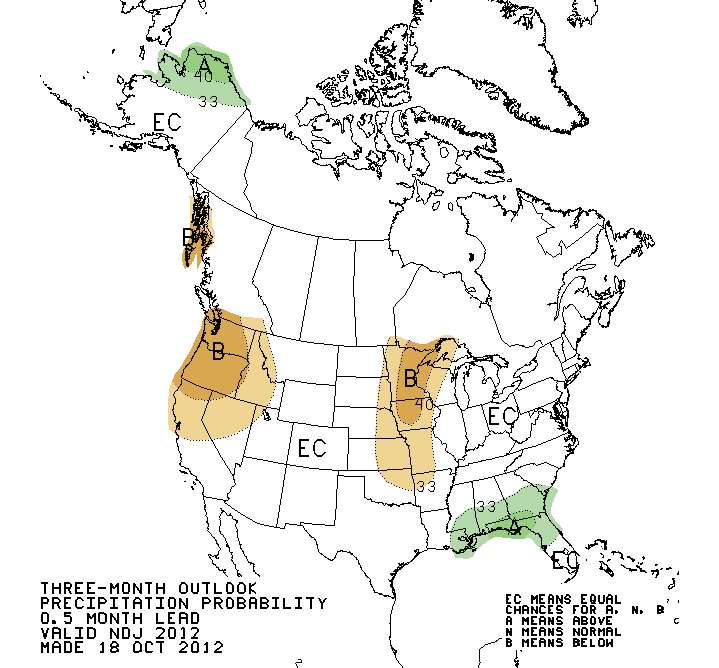
(Image: National Weather Service)

Fresh off our red flag fire warnings of late, late summer, Seattle has gotten almost three inches of rain in October. But don’t get used to it, cautions the Seattle branch of the National Weather Service. The trend is for a weak El Niño winter, or even a neutral winter, and that “indicates an increased likelihood of below-median precipitation for the Pacific Northwest.” A wildcard, they say, is the Arctic Oscillation, which could cool things off…or not.

Another caveat is that “below-median precipitation” doesn’t preclude floods from errant Pineapple Expresses.

University of Washington meteorologist Cliff Mass welcomes a neutral winter. Though very big storms are rare in the Northwest, he says, they tend to occur most often during neutral winters. Flourishing a plot-map, Mass announces:

The red squares indicate a major windstorm year (like the 1962 Columbus Day Storm or the 1993 Inauguration Day Storm). All of them are associated with temperature anomalies in the tropical Pacific between plus or minus one. This year will be in that range!

What were those storms like, you might ask, if you are newer to town, or to life in general. It’s all chronicled on the internet for you.

  1. Columbus Day Storm: In sheer gustiness of wind, as indicated by the ratio of maximum gust speed to sustained wind speed, called the gust factor, the Columbus Day Storm behaved more like a hurricane than a typical midlatitude cyclone
  2. Inauguration Day Storm: At least 79 homes were destroyed, 581 suffered major damage, and 1,702 experienced minor damage. Power was terminated to about 750,000 customers in the Puget Sound Area.

“I could show you a similar figure for floods or snowstorms, but that would only scare you,” concludes Mass, emphasizing once more, though, that a neutral winter doesn’t always bring this kind of excitement. (In the 47 years from 1949-50 to 1995-96, there were 14 neutral winters.) Most often, it brings what’s known as a “normal” winter, though with the weather acting as it has of late, you can be forgiven for not knowing what normal is anymore. Maybe the most reassuring thing is that whatever’s coming, with coastal radar, we’re better able to see it in time.

Seattle’s Record-Setting Sunny Stretch Starting to Get on Locals’ Nerves

Seattle weather. Wait…Seattle weather?

Reports University of Washington meteorologist Cliff Mass: “[F]or those that love weather records, it is official. The August-September precipitation at Seattle-Tacoma Airport (of .03 inches) was the driest in the 65-year record at that location.” On average, August (Seattle’s second-driest month after July) would bring about an inch of rain, September, an inch and a half. October averages almost three and a half inches of what’s known colloquially as “the wet stuff.”

UPDATE: Mass looks into the existence of Summer SAD.

As of today, the National Weather Service’s Seattle bureau has a 7-day forecast that’s nothing but blue skies and Sol-shine. In other areas this news might be greeted with cheers and flip-flops, but in Seattle, there’s an undercurrent of anxiety. The Stranger‘s Bethany Jean Clement sounds like she might be misting herself as she writes, “for those of us who grew up here, this long, long spell of no rain is just creepy.”

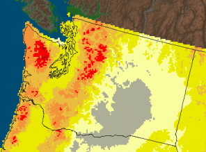
Departure from average precipitation levels, last 60 days (Image: NWS)

In fact, it’s not just creepy–it’s dangerous, as Red Flag warnings indicating extreme fire danger have been flying for Western Washington, whose outdoorsy population is not used to the foliage bursting into wildfires. 150 acres burned near Shelton yesterday and overnight.

“We have not seen wildfire conditions this bad in October in a lifetime,” said Commissioner of Public Lands Peter Goldmark. The DNR suggests you avoid doing anything that generates sparks or heat. No parking your car in dry grass. No target shooting. Certainly no campfires.

East of Seattle, the citizens of Leavenworth are preparing for Oktoberfest and celebrating clearer skies and cleaner air–eastern Washington’s air quality has been hard hit by the summer’s wildfires. It was a hazy summer all over.

And what about the skiing? The winter will in theory be of the El Niño persuasion, though not that forcefully, and KING 5’s Jeff Renner admits that “typically that means a warmer, drier winter than average.” Cliff Mass is holding out hope, you sense, that it’s a neutral winter instead, neither El Niño nor La Niña, “since the biggest of the big events (floods, windstorms, even snowstorms) tend to occur in neutral years.”

Unfair! Washington State Steals Southwest’s Desperately Needed Rain

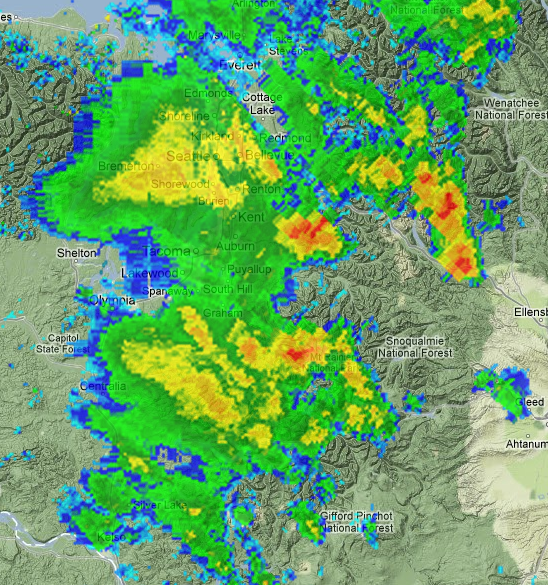
Screenshot Friday morning from UW Atmospheric Sciences radar animation

Hey, what gives? Early- to mid-July is normally the time when summer arrives and Seattle dries out quite a bit–on average, it’ s our driest month of the year–but instead the Puget Sound area has been rocked by an unusual string of thunderstorms, thundershowers, and flash floods. This morning’s downpours are courtesy of Hurricane Fabio, which two days ago was 670 miles west of the southern tip of Baja California. Can’t we build a huge fence?!

KOMO’s Shannon O’Donnell explains this out-of-market weather is due to a series of giant sucking lows located above us:

Since that point in early July, we’ve more or less kept an upper level low somewhere nearby the Northwest.  The circulation wrapping around the low has continued to pull up monsoonal moisture from the Desert Southwest, allowing thundershowers than are commonplace in Arizona and New Mexico to meander all the way up north into our neck of the woods.

This has given University of Washington meteorologist Cliff Mass the chance to explain to you what altocumulus castellanus clouds are and why you shouldn’t shelter under trees, along with a brief history of notable flash floods of the past, compared to cloudbursts this time: “For example, a thunderstorm hit the Okanagan area near Omak around 2:30 p.m. Sunday afternoon, with over two inches over a one-hour period at the Malot AgWeatherNet Station.”

In meteorological theory, this particular moisture-vacuuming low will move north by this afternoon, and we will back into our marine-layer-morning, afternoon-sun pattern for Saturday–followed by yet another upper-level low Sunday night, bringing clouds and rain. Get used to that meteorological two-step, because KOMO’s Scott Sistek says NOAA doesn’t see much reason for August to be different.

While the rest of the U.S. sits panting with its tongue hanging out, the Northwest is enjoying substantial cooling produced by coastal upwelling. As of July 18, Sistek reports, “the thermometer at the University of Washington Atmospheric Sciences Department which, unlike Sea-Tac Airport, keeps an actual minute-by-minute log of the weather station atop their roof,” has registered just 50 minutes of 80+ degree weather. That’s actually less than last year. (In fairness, if you go by what makes a Northwesterner deliriously happy, a balmy mid-70s, we have reached that mark 12 days over the past 48.)

July 4th is Transition Day!

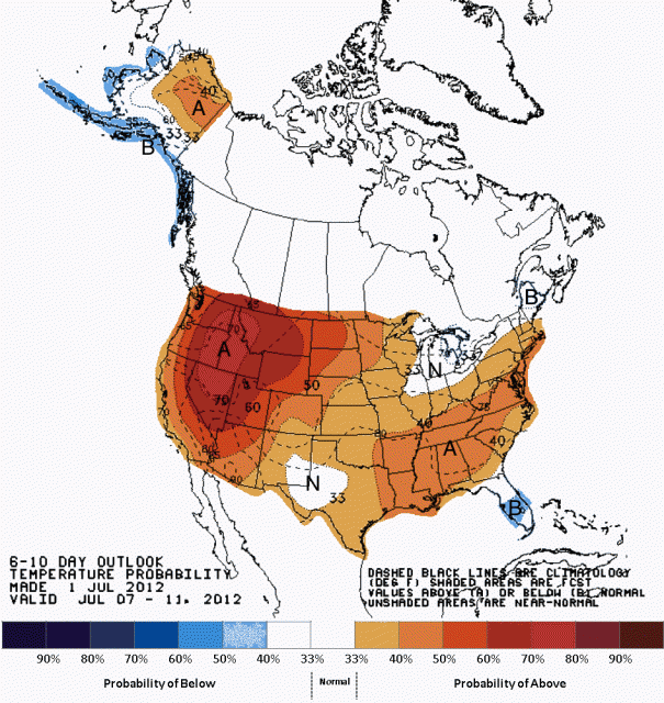
Climate Prediction Center’s 6-10 day outlook

Okay, July Fourth is also Independence Day, on which we make the British look sheepish about their imperialist history and then blow our fingers off with fireworks. But for Northwesterners, as Cliff Mass reminds us, July Fourth is also the day that summer begins. (Right, sometimes it’s July Fifth.)

This year, says Mass, we can expect the Fourth to be “the transition day, but one that should be dry–particularly around fireworks time”–so be ready to fire up the grill. The big local event is the Family 4th at Lake Union, presented by Starbucks. Though the fireworks have to wait for dark, there’s fun planned for the whole day, beginning at 10 a.m. in Lake Union Park and noon at Gas Works:

One Reel, the non-profit producer of the Family 4th, has collaborated with The Center for Wooden Boats and future South Lake Union resident Museum Of History & Industry (MOHAI) to link their event with another favorite summer tradition, the Lake Union Wooden Boat Festival.

With the Fourth behind us, “we transition to meteorological nirvana, as the persistent trough over the NW moves offshore and ridging develops over western North America,” adds Mass, in what certainly looks like English.

It’s that trough that brings in cool, cloudy air from the Pacific, so with it gone, things brighten up appreciably. The Climate Prediction Center provides the map above, in which oranges and reds indicate the probability of above-average temperatures. For most of the year, the Northwest has been on the bluer end of that scale, but finally we will have a chance to swelter a little, and make sotto voce disparagements of people who wear flip flops at inappropriate venues. Enjoy.


The Northwest Remains Cool on Summer Heat

The Northwest’s A/C is on and working around the clock.

I don’t know if you know this, but tomorrow is International Surfing Day. There’s going to be an 8-hour webathon, sponsored by Surfrider Foundation, TransWorld SURF, and SME. I’m told this includes professional surfers, celebrities, and environmental heroes; and a bikini fashion show, surfboard previews, and live music.

Believe it or not, people surf all around the Washington coast, just while clad in wetsuits, usually. You have be serious about it because as is often the case with Northwest weather, things zig when they should zag. UW meteorologist Cliff Mass has a post that asks: “Why in the world would ocean temperatures get cooler during summer?” The answer is upwelling–water getting pushed up from chillier depths by a northerly wind pattern and the Coriolis effect.

Just as the weather warms, the coastal waters get colder. If you bounce among the buoys off the coast, you can see water temperature ranges now between 57 and 45 degrees. It’s actually colder to the south, because their warmer air temperatures have instigated upwelling already. So for International Surfing Day, the Washington coastal waters will be warmer than at the California-Oregon border.

Drylanders don’t have much to crow about on the weather front. KOMO’s Scott Sistek says it’s come to his attention that we’ve had exactly one bright, sunny day so far this June. Apparently this is taking a toll on our golfing. Nor is Sistek going to cheer you up with promises of an early summer: “long range forecasts for the rest of the month–save Thursday–are looking like continued gray and damp as the general theme.” Looks like summer will be on track to start sometime after July 4.

Over on KIRO, Morgan Palmer is already looking ahead to winter, and notes that weather models are showing the possibility of an El Niño winter. Palmer quotes the Climate Prediction Center: “About half of the models predict a transition from ENSO-neutral conditions…to El Niño during the Northern Hemisphere summer, with El Niño continuing through the remainder of the year.” There are two levels of probability there: first, that we’ll get an El Niño pattern, and secondly, that it will produce a particular kind of weather. Often it results in a less-wet, less-chilly winter. Then again, it may not.

But you know what they say about the weather around here: It’s terrible. Put a sweater on.