Tag Archives: congestion

Forget Mercer Street! Mercer is Dead (Until Mid-2015)!

Mercer_Spring_2013_Flow
Mercer_Weekend_Closure
mercerw_underpassrenderingS

Map of the May 17-20 closure of Mercer and SR 99 (SDOT)

The planned 2-way Mercer Street (SDOT)

Last weekend’s closure of the I-5 on- and off-ramps at Mercer Street caught a good deal of Seattle Opera patrons, trying to head to McCaw Hall on Seattle Center campus, off-guard, even if they weren’t taking Mercer at all — the closure shifted traffic to the already heavily-used Denny Street, slowing it down as well. Riders on the perennially-late and packed 8 bus that runs cross-town on Denny were caught up in the congestion, too.

The Opera, which had alerted its patrons in advance, still held the curtain for a few minutes because of the traffic jam. With work on Mercer ongoing, they warn that at this summer’s performances of the Ring — where due to Wagnerian length they can’t afford a late start — it will be even more critical that opera-goers plan to arrive with plenty of time to spare.

The news from Seattle’s department of transportation is to expect these kind of delays, over the next two years; “a trip near Seattle Center will take five or 10 minutes longer,” is how Mike Lindblom puts it in the Seattle Times. That seems likely to be an average, with busy nights at the Center tying up traffic for longer.

If you need to travel Mercer, you likely want to subscribe to email alerts from here on out, as Mercer Corridor project construction brings new closures and lane restrictions.

As of today through Friday, May 17, Westbound Mercer Street (and Broad Street) will narrow to a single lane from Westlake Avenue North to Harrison Street. Tomorrow, Friday, eastbound Mercer will be a single lane from just west of Dexter and 9th from about 8 a.m. to 4 p.m. For the next three weeks, northbound 9th Avenue North, from just south of Aloha to 8th, will have a single northbound lane.

Then, the weekend of May 17 to 20, SR 99 will close between Valley Street and the southern end of the Battery Street Tunnel, while Mercer Street will be fully closed to traffic between Fifth Avenue North and Dexter Avenue North. SR 99 traffic will be directed to I-5 at the bottleneck, so expect slow going there, while Mercer traffic will detour over to Denny from 5th to Dexter, and back to Mercer.

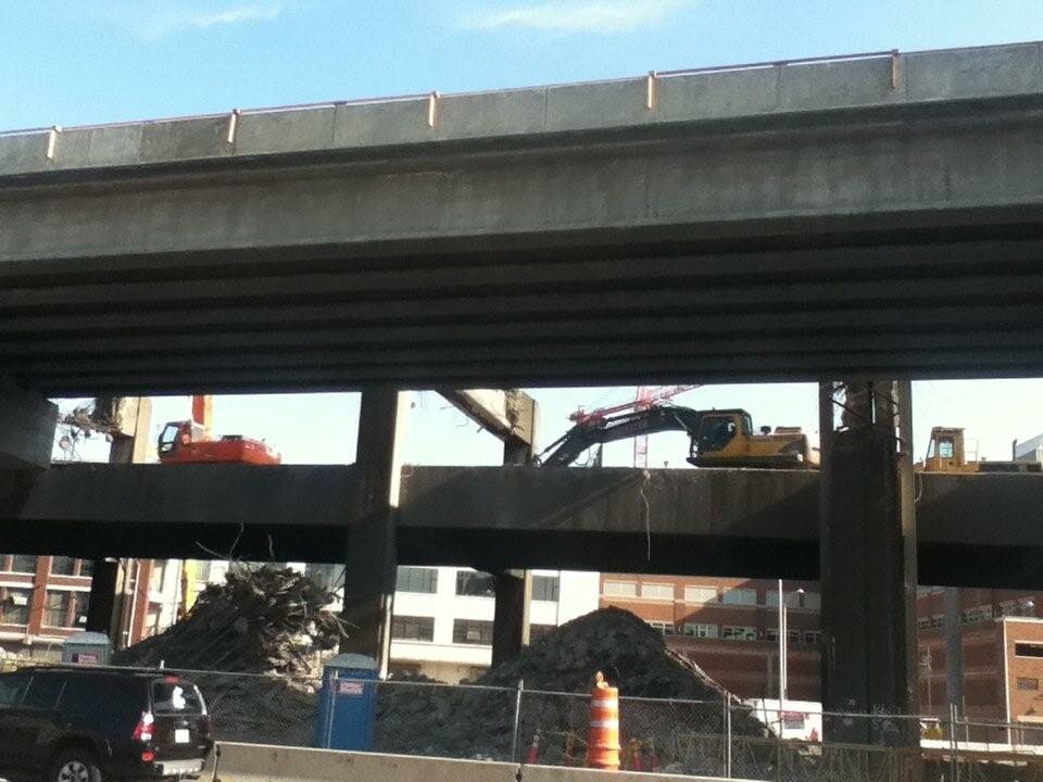
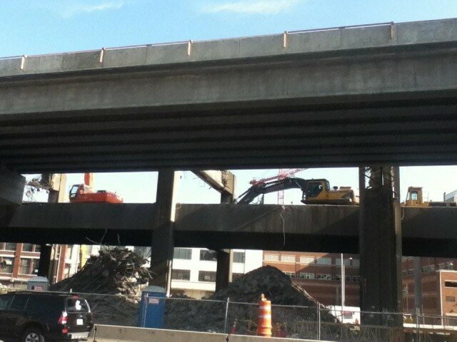
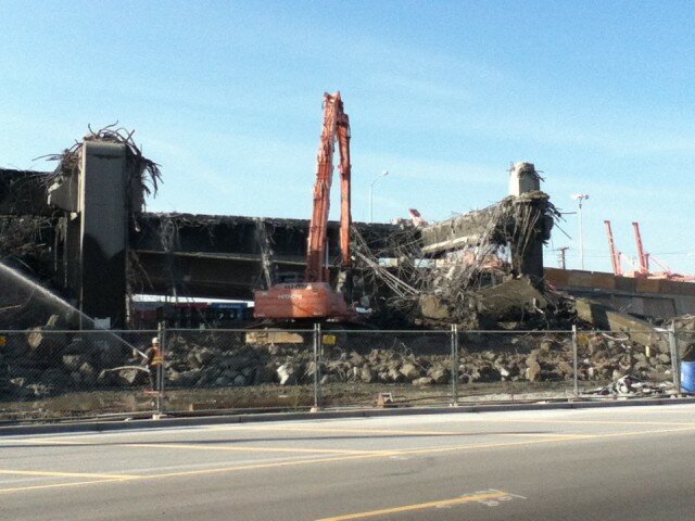
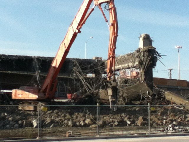
The weekend closure is to help SDOT prepare for the demolition of  the eastern half of the SR 99 bridge over Mercer; once that’s out of the way, crews can work on widening Mercer between 5th and Dexter, to allow two-way traffic. That part of the Mercer Corridor project is expected to take until mid-2015. After the weekend closure, says SDOT:

  • Mercer Street will be reduced to two eastbound lanes between Fourth Avenue N and Ninth Avenue N.
  • SR 99 traffic will be shifted to the west side of the roadway between Valley and Harrison streets. Two lanes will remain open in each direction.
  • The northbound SR 99 off-ramp to Mercer Street will be permanently closed. A new signalized intersection at Republican Street and Dexter Avenue N will be available for northbound SR 99 traffic to reach South Lake Union.
  • Local access to Taylor Avenue N via Mercer Street will be maintained.
  • Sidewalks on Mercer Street will be impacted during this work. The sidewalk on the north side of Mercer Street will be closed between Fifth Avenue N and Dexter Avenue N. The sidewalk on the south side will remain open to pedestrian traffic.

To help with congestion, Broad Street will reopen to eastbound traffic, and traffic southbound on 5th will be able to turn left onto Harrison to get to eastbound Broad Street.

When finished, motorists will be able to take the Mercer Street exit from I-5 and drive directly to Seattle Center, which should be an improvement. (You could already drive eastbound from the Center to I-5 on Mercer, so that won’t change much.) Equally important, as South Lake Union develops, is the transformation of Mercer on behalf of pedestrians and bicyclists. Its earlier incarnation hadn’t much room for either, especially where Mercer ducked beneath SR 99.

Seattle Takes Light Rail Train to Job Growth

(Photo: MvB)
(Photo: MvB)

It’s a nationwide trend: As jobs return, so do public transit passengers. The American Public Transportation Association says a record 10.5 billion trips in 2012 would have closer to 10.6 except for the impact of Hurricane Sandy on all modes of public transit along the Eastern seaboard. The association attributes the “second highest annual ridership since 1957″ to the cost of gas and an improving employment picture. (Thanks to the Slog, who alerted me to the study.)

Currently, the national average for a gallon of gas is $3.69 for regular, $4.01 for premium. (The highest recorded average was summer of 2008: $4.11 for regular.)

In a related Reuters story, APTA spotlights Seattle, “where transit rides rose 11.8 percent over the year as the metropolitan area added more than 30,000 jobs.” From January 2012 to January 2013, the state of Washington added some 65,800 jobs (98 percent of which were in the private sector), with the unemployment rate now holding steady at around 7.5 percent statewide, 6.3 percent in Seattle.

SIDEBAR: In fact, the state can’t quite believe the numbers are as good as the federal Bureau of Labor Statistics says: an increase of  24,100 jobs from December to January that may not be wholly new jobs, but may be due in part to seasonal adjustments and a change in the way the BLS reaches those figures. “Based on historical patterns,” explains chief labor economist Joe Elling, “Washington employment typically falls by 61,300 from December to January.” This year, the BLS estimated a loss of just 37,000, resulting in that “jobs increase” of 24,100. Elling expects these preliminary numbers to be revised to be more in line with an observed 5,000-jobs-per-month trend.

Nonetheless, Seattle is all over the APTA report on top transit ridership in the country during 2012. The Seattle Streetcar‘s ridership jumped five percent (750,294 boardings in 2012), with its First Hill line due to open in spring-summer of 2014 — and that line’s ridership is projected to exceed that of the South Lake Union stretch of rail. (There’s an ongoing fight to bring back the Waterfront Streetcar service, which used to carry several hundred thousand passengers a year as well.) Sounder commuter rail was up eleven percent (more than 2.8 million boardings in 2012), as was Central Link light rail (8.7 million boardings, up almost one million from 2011), reports Sound Transit.

King County Metro’s workhorse bus system carried 4.6 percent more passengers, as well — more than 115 million trips. Some of the boost in ridership can be credited to Viaduct Replacement Project construction and tolling on SR 520, says Metro chief Kevin Desmond, who has to fight for funding to maintain service levels, let alone deal with ridership increases. (Video of Desmond making his case available at Seattle Transit Blog.)

Funding for transit infrastructure is also up: “Last year 49 out of 62 transit-oriented state and local ballot initiatives passed,” said APTA President and CEO Michael Melaniphy, arguing this represented a sea change in public willingness to pay. The rise of transit dovetails with findings in a mid-2012 study, commissioned by the U.S. Conference of Mayors, that tied U.S. metro economies to transportation infrastructure. Have legislators understood this? Seattle Times columnist Jon Talton, whose article surfaced the report for me, wonders.

“If Seattle-Tacoma-Bellevue were a separate country — and many legislators in Olympia apparently believe this to be so — it would have the world’s 53rd largest economy, just behind Israel and ahead of Portugal and Chile,” Talton writes. That $242-billion economy (in 2011) placed Seattle twelfth out of 363 U.S. metros, behind Boston (9th) and San Francisco (8th). It’s in the neighborhood of those of the states of Missouri, Louisiana, or Connecticut. In the decade between 2001 and 2011, it grew an average of 4.4 percent each year.

Taken together with Olympia, the Seattle MSA accounts for more than 70 percent of Washington’s economic product, with about half of the state’s nearly seven million inhabitants. By 2042, the study authors expect the Seattle MSA to grow 40 percent, to nearly five million. By 2020, they anticipate another 285,000 jobs.

Interestingly, since 2000, Seattle’s congestion costs (figured by cost of gas and driver time) have actually fallen: to $942 per year in 2010 versus $1,102 per year a decade earlier. That puts the Seattle MSA in tenth place nationally, behind Boston (9th), Denver (8th), and San Francisco (7th).

Congestion also impacts freight tonnage, where Seattle is twelfth, ahead of Boston this time, but behind Minneapolis. Usually, exports represent between 15 and 16 percent of Seattle’s gross metropolitan product (that ratio changed during the recession, edging into the 20s as exports stayed strong).

“Investment in roads, rails, and other forms of transportation,” claim the authors, “will help relieve the bottlenecks impeding economic expansion,” though they also write that “road capacity has not kept up with passenger growth, and public and alternative transportation usage and development has not been substantial enough to pick up the slack.” They also envisioned the average price for a gallon of gas falling to $3.11 per gallon at the end of 2012 (remember it’s around $3.70 now).

Doesn’t it seem that, in metro areas particularly, public transportation would come first, with roads taking up the slack?

The demand for transit in Seattle seems an indicator that the current ratio of roads to transit is unappealing to metro voters. A $10-billion transportation package unveiled by the state’s House Democrats would spend the vast majority of that $10 billion on new road projects, with $1 billion for maintenance and even less than that for public transportation. It does not help fund the 520 floating bridge replacement, which remains more than a billion dollars short, or the SR 99 tunnel. It doesn’t sound like it has yet sunk in, as STB announces, “Transit Supporters are the Key Swing Vote.”

Ballmer and Nordstrom Brothers’ New Triangle Offense May Get NBA’s Attention

Detlef's fast break on Twitter

Yesterday a buzz started building that something new was afoot in the attempt to bring the NBA back to Seattle via a new stadium. Insiders were whispering about a game-changer. This morning, it’s clear what that is: Hedge-fund manager Chris Hansen revealed three big investor names on KJR Sports Radio: Microsoft’s Steve Ballmer, and Erik and Peter Nordstrom.

Geekwire explains why Ballmer might have wanted to let Hansen take lead on the project.

In retrospect, Mayor Mike McGinn’s visit with the NBA’s David Stern doesn’t look so hat-in-hand, though Hansen’s people claimed no knowledge of “Loose Cannon” McGinn’s plans. King County Executive Dow Constantine, an early political supporter of the effort, released this statement: “The names of Steve Ballmer and Peter and Eric Nordstrom add additional strength and credibility to this proposal, and even greater assurance of the financial stability of the investment team that is working to bring the Sonics back to Seattle.”

“Financial stability” is the key phrase in that statement, since the new stadium plan has been getting pushback, notably from the Municipal League of King County, who released a broadside of criticisms largely focused on financing assumptions and congestion mitigation issues. As summarized in the Seattle Times, the League’s argument referenced the speed at which KeyArena became “unsuitable” for NBA economics:

KeyArena didn’t deteriorate, the report says, so much as it was no longer big enough to accommodate the space deemed necessary for the new standard of arenas. If a region has to replace its arena every 10 to 15 years, it suggests that the new arena’s improvement fund should require annual deposits of at least $20 million. Are investors prepared, the League asks, to provide funding at that level?

If the investor group include Steve Ballmer and the Nordstroms, the answer to that question is suddenly less worrisome for people who’d like to see the Sonics return.

That leaves the concern, still, of the Port of Seattle and Mariners that two stadiums is company and three is a crowd. Yet the Port and the Mariners have different interests, I think–while the Mariners are fighting for market share, the Port may simply be looking for help (in addition to the $73 million in tax revenue they project to receive in 2012) paying for SoDo transportation infrastructure that is needed whether there’s a new stadium or not.

The Viaduct is a Hard Habit to Break

002
EXIF_JPEG_T422
EXIF_JPEG_T422
EXIF_JPEG_T422
IMG_0028
IMG_0041

Alaskan Way Viaduct (Photo: Arne Christensen)

Alaskan Way Viaduct (Photo: Arne Christensen)

Alaskan Way Viaduct (Photo: Arne Christensen)

Alaskan Way Viaduct (Photo: Arne Christensen)

Alaskan Way Viaduct (Photo: Arne Christensen)

Alaskan Way Viaduct (Photo: Arne Christensen)

002 thumbnail
EXIF_JPEG_T422 thumbnail
IMG_0028 thumbnail
IMG_0041 thumbnail

Last weekend, the Washington Department of Transportation opened a closed Viaduct to pedestrian traffic, so people could say their (first) goodbyes to the spit-and-baling-wire structure in person. It wasn’t the end of the entire Alaskan Way Viaduct–just the end of the southern end, which is being torn down this week, a project that is right on schedule. You can follow along yourself via WSDOT’s construction cameras.

Commuters seemed willing and able to find workarounds for most of the week, until Thursday, when #viadoom struck. The morning commute was rough, the afternoon, rougher, as the Seattle Times‘s Mike Lindblom recounts:

Traffic entering Seattle on I-5 was stop-and-go from Shoreline to downtown, starting as early as 3 p.m. and continuing past 6 p.m. A seven-mile trip from Northgate to the convention center took 40 minutes, according to the INRIX traffic-data firm.

As regional drivers tried to miss Seattle, congestion built on I-405 southbound in the Canyon Park area of Bothell, where speeds were 23 mph, or half the usual pace.

Come Monday, it’ll be all right, or at least back to the normal back-ups–the Viaduct will reopen at 5 a.m. on October 31. on Saturday.

Occasional SunBreak contributor Arne Christensen went down to watch some of the weekend’s deconstruction, noting that people up on the Viaduct were taking pictures of the ground through the gaps in the structure’s expansion joints.

Puget Sound Business Journal photographer Marcus Donner assembled this time-lapse video of the Viaduct work:

Relive the moment of collapse on YouTube from a variety of angles. The end of the southern end of an era.

The Autumn of Our Traffic Backup Discontent

The 520 Bridge with traffic, unlike this weekend when it will be closed (Photo: MvB)

Traffic was going to be a little hinky at times anyway this weekend, thanks to Saturday Huskies (12:30 p.m.) and Sounders (7:30 p.m.) games, but WSDOT is also going to be working on the 520 bridge, which is slightly less old than its namesake, Albert Rosellini, who died this week at 101.

Well after the Huskies play, at 8 p.m., both directions of the SR 520 floating bridge and highway and all ramps between Montlake Boulevard and I-405 will be closed until 5 a.m. Monday. You will be able to get on 520 at Montlake and get to I-5; it’s just east to the bridge that’s closed for the weekend. If you normally drive I-90, expect to see a lot of new, somewhat harried faces, especially just before the Sounders game starts.

There’s also the Puget Sound Heart Walk (which has raised $1.2-ish million of its $1.6-million goal). That begins at 9 a.m. Saturday, with walkers taking off from Fisher Pavilion, walking around Seattle Center, and heading down Second Avenue to Seneca and back. King County Metro is publishing a list of reroutes, so don’t get smug, bus riders.

Think of all this as practice for the Alaskan Way Viaduct closure coming up on October 21. For this news, WSDOT grabs the boldface pixels: “At 7:30 p.m. Friday, Oct. 21, 2011, the State Route 99 Alaskan Way Viaduct will close for nine-days.” Nine-days is so long, it gets a hyphen!

The nine-day closure of the viaduct will be the longest ever for a Seattle area highway. With one of the major north-south highways through Seattle closed, drivers from across the Puget Sound region will be significantly affected by the closure. Even if you commute from Lynnwood and Bellevue, you will see increased congestion as the nearly 110,000 drivers that use the viaduct daily look for somewhere else to go.

Where’s your bus? Writes Metro’s Kevin Desmond: “Metro will move 11 routes from the viaduct to Fourth Avenue South. After the viaduct reopens, those routes will begin using the new viaduct bypass.”

This closure will be interesting to watch–if not experience–because nine days is long enough to force behavior patterns to change. If there’s no carpocalypse, people may ask themselves why the state and city chose the single most expensive Viaduct replacement option on the table.

On the other hand, if carmagedd0n does come, that’s a glimpse of life in the near future, as construction ramps up. Per Seattlepi.com: “The $30 million set aside to increase Seattle transit options during the construction of the tunnel replacement for the Alaskan Way Viaduct will run out by 2014 – two years before the project is finished, the City Council was told Tuesday.”

With Tolls, New Larger 520 Bridge Could Serve Half as Many

Comparison of old and new bridge footprints (Image: WSDOT)

There are two substantially different rationales that Washington’s Department of Transportation has advanced for its choice of a new, larger 520 bridge across Lake Washington. First, the existing bridge is unsafe, vulnerable to earthquake and wind. Secondly, the 1963 bridge was designed to carry a maximum of 65,000 vehicles per day, and today carries up to 115,000 (but not speedily.)

While I don’t think anyone is arguing the first point, it’s jarring then to see WSDOT’s projections for the new bridge show vehicle traffic not reaching 100,000 per day again until 2032, and topping out around 118,000 by 2052. This is not to disregard time savings, but at a cost of $4.65 billion, to wonder if there might be a better way of achieving them.

Why would so much traffic divert? Tolls. As Mike Lindblom reports for the Seattle Times, WSDOT’s financial projections call for some 48 percent of existing traffic to seek other routes, thanks to $3.50 Good to Go tolls on the bridge during peak hours (that’s $5.00 if you haven’t signed up with Good to Go). The tolls are supposed to increase 2.5 percent annually until 2017, at which time they will increase 15 percent.

WSDOT has to be hard-nosed with these projections, which differ from previous estimates, because they are being used to secure investment funding. It makes sense for them to reassure conservative investors by saying, essentially, “Look, even if only half the people who currently use the bridge pay the tolls, we still raise enough money to pay you back.” (Mention of Tim Eyman’s Initiative 1125, which would likely sink tolling plans completely is absent from the financial study.)

That said, as they define the space of possibility to include such a drastic diversion, it does make you wonder what the bridge-driving taxpayers’ return on investment will be.

As every story on the bridge’s construction will tell you, $4.65 billion is so much money that the project is still missing $2 billion. Back in 2010, the Legislature authorized funding of up to $2.62 billion for the 6-lane bridge, and a 6-lane connector to I-405 at its east end. The bridge is supposed to open in 2014.

Seattlepi.com summarizes the incremental-build result for you: “That means a six lane bridge would link up with the same four-lane configuration that exists now between the lake and I-5,  which some fear will only add to bottlenecks west of the shoreline.” (“Some,” I think in this case means anyone who has spent more than five minutes thinking about it.)

People in that latter group are the Coalition for a Sustainable 520, and their attorney David Bricklin. The group filed suit in U.S. District Court in Seattle on September 2, naming WSDOT and the Federal Highway Administration, and declaring that the project’s Final Environmental Impact Statement includes:

…a failure to include all reasonable alternatives in detail; a failure to adequately describe the existing environment; a failure to adequately describe the significant adverse environmental impacts of the project; a failure to adequately analyze measures to mitigates the project’s significant adverse environmental impacts; and a failure to describe the project’s unavoidable significant adverse environmental impacts.

An email from the group adds:

The state has applied for shoreline permits for the entire 520 project, not just the partial bridge that has been approved for construction. These permits cover the areas near us: Portage Bay, Union Bay, the Montlake cut area, and near Madison Park/Laurelhurst. In general, the state plans to harm these areas, and to provide compensating mitigation further away…on the Cedar River, in Magnuson Park, uplands near Union Bay.

We believe that the environment near us should not be damaged this way. It is already quite stressed enough, and further stresses could tip it over the edge. So we want mitigation to be right in the area.