In fairness, the rest of the U.S. would have loved to have had our August: “highs” in the mid-70s, and fairly hurricane-free. The National Weather Service notes that: “As of August 28th, Seatac airport has only had 0.12 inches of precipitation during the month of August. If no more precipitation occurs this month, it will rank as the 6th driest August since 1945.”
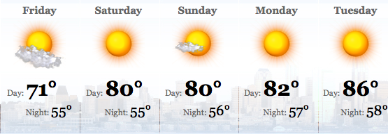
Now we’re looking at low-80s for Labor Day Weekend, according to KOMO Weather. But wait, there’s more. We could actually see high temperatures next week that count as high to people outside the Pacific Northwest’s air-conditioned zone–90 degrees even!
You can blame it on the rain elsewhere, says the Weather Service:
Over the next several days Tropical Storm/Typhoon Talas south of Japan is expected to move north. As it does so, it will build a strong ridge east of Japan resulting in cold air dumping into the central Pacific from the Arctic. This, in turn will cause a strong ridge of high pressure aloft to form over Western Washington, giving a late summer warm spell.
Sidebar: On his blog, meteorologist Cliff Mass offers Fox News the award for publishing the “absolutely dumbest opinion piece I have read in a long time“–titled “Do We Really Need a National Weather Service?” it was written by not one but two people who seem to be unaware that all of the private enterprise they mention get their weather data by scraping NWS sites.
Here’s the National Weather Service’s chatty little discussion of the forecast:
AN UPPER RIDGE IS STILL ON TAP FOR THE WEEKEND…AND ALTHOUGH ANOTHER UPPER TROUGH MOVES INTO THE NE PACIFIC THIS TIME IT WEAKENS AND MOVES OFF INTO NRN B.C. AND ALBERTA WITH THE 500MB HEIGHT OVER WRN WA STAYING UP AROUND 5800M. SO IT IS A PRETTY GOOD BET THAT WARMER TEMPS AND NO MARINE CLOUDINESS ARE ON TAP…CLEAR SKIES AND SUNNY DAYS FOR THE HOLIDAY WEEKEND.
I SUPPOSE SOME CIRRUS MAY SKIRT BY AS THE RIDGE TEMPORARILY DENTS IN…BUT BY LABOR DAY A STRONGER TROUGH WELL OFFSHORE LOOKS TO HELP PUMP UP THE RIDGE ALONG THE WEST COAST. THIS IS THE SAME SOLUTION AS THE 00Z RUN YESTERDAY. BY THE MIDDLE OF NEXT WEEK THIS LATEST 00Z RUN OF THE GFS HAS A RATHER WARM DRY AIR MASS OVER WA UNDER THE STRONGEST RIDGE WE HAVE SEEN OVER WA THIS SUMMER AND ALTHOUGH THERE HAVE BEEN MANY ENSEMBLE MEMBERS WHICH HAVE NOT AGREED WITH THE WARM SOLUTION THE PAST FEW DAYS BOTH THE 5 WAVE CHART FROM THE OPERATIONAL GFS AND THE ECMWF CERTAINLY BACK UP THE CPC 6-10 AND 8-14 DAY OUTLOOKS FOR ABOVE NORMAL TEMPS.
THE AVERAGE NUMBER OF SUMMER DAYS AT SEA TAC WHICH SEE A HIGH OF 90 DEGREES OR WARMER IS JUST THREE DAYS…I SUPPOSE WE COULD FINALLY GET OUR ALLOTMENT OF HOT DAYS ALL IN A ROW NEXT WEEK IF THIS GLOBAL MODEL SOLUTION FOR NEXT WEEK STICKS.
Soak up all the sunshine you can, because as KOMO meteorologist Scott Sistek reports, NOAA “are sticking with the recent forecast that neutral conditions are going to remain through November, but it’s 50/50 whether we’ll then stay neutral or go toward La Nina.” Currently, Sistek says, the odds are rising ever so slightly for “another cooler and wetter than normal fall and winter.”