Tag Archives: heat wave

That Weekend Pre-Summer Mother’s Day Scorcher You Ordered

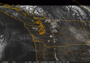
NWS radar as of Friday morning, showing clear skies

It’s Friday morning, and thus time to begin thinking seriously about the weekend. Despite the relatively air-cooled sunshine of the past few days, says UW meteorologist Cliff Mass, “we are about to have [a] heat wave–one that will bring near 80F temps to Seattle, 85F to Portland, and near 90F in Medford.” Plus, he adds, “Monday will be warm as well.” Three-day weekend! For the moms.

That’s right, in case you’ve forgotten, Mother’s Day is this Sunday. But first, Saturday, which the National Weather Service tells us will reach 77 degrees; then Sunday, even warmer, near 80; and Monday, high of 79: All of which is to say that we have string of three great days in front of us. Use them wisely, because a moist, chilly June Gloom is likely waiting for you, just around the corner.

Speaking of Mother’s Day, a few items: Grand Central Bakery suggests la mama might like an 8-inch round Coffee Cake topped with local fruit, a tender Coconut Layer Cake, or a Strawberry-Rhubarb U-Bake Pie. Five percent of Mother’s Day purchases are donated to local charities that help low-income mothers. If your mom’s a tea lover, Choice Organic Teas is giving a private tour ($50, reservation required) of their Seattle, certified organic tea factory with a tea tasting–that’s Saturday, not Sunday, from 11 a.m. to 1 p.m. Comes with complimentary mug and three boxes of tea!

Brunch is always a hot ticket: I’m not telling you where I’m going because I don’t want hordes of people there, you’ll have to try out the new brunch at Vios–AW DAMMIT!–another time. Other Seattle options: Urbane (3-course prix fixe), the venerable Ivar’s Salmon House, Café Campagne naturellement, any of T-Doug’s joints. In Kirkland: bin on the lake (two words: bacon beignets) and Beach Café also have special brunches.

Just remember it’s going to be hot, and you’ll need to alternate the mimosas with water. Remember what happened last year. It’s always embarrassing to have to bail mom out for a D&D.

Get Ready for Summer in Seattle This September

KOMO Weather looks on the bright side

In fairness, the rest of the U.S. would have loved to have had our August: “highs” in the mid-70s, and fairly hurricane-free. The National Weather Service notes that: “As of August 28th, Seatac airport has only had 0.12 inches of precipitation during the month of August. If no more precipitation occurs this month, it will rank as the 6th driest August since 1945.”

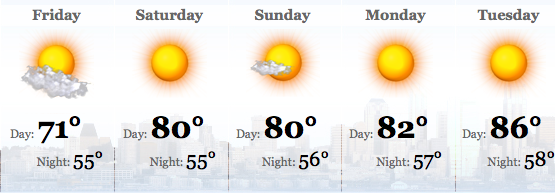
Now we’re looking at low-80s for Labor Day Weekend, according to KOMO Weather. But wait, there’s more. We could actually see high temperatures next week that count as high to people outside the Pacific Northwest’s air-conditioned zone–90 degrees even!

You can blame it on the rain elsewhere, says the Weather Service:

Over the next several days Tropical Storm/Typhoon Talas south of Japan is expected to move north. As it does so, it will build a strong ridge east of Japan resulting in cold air dumping into the central Pacific from the Arctic. This, in turn will cause a strong ridge of high pressure aloft to form over Western Washington, giving a late summer warm spell.

Sidebar: On his blog, meteorologist Cliff Mass offers Fox News the award for publishing the “absolutely dumbest opinion piece I have read in a long time“–titled “Do We Really Need a National Weather Service?” it was written by not one but two people who seem to be unaware that all of the private enterprise they mention get their weather data by scraping NWS sites.

Here’s the National Weather Service’s chatty little discussion of the forecast:

AN UPPER RIDGE IS STILL ON TAP FOR THE WEEKEND…AND ALTHOUGH ANOTHER UPPER TROUGH MOVES INTO THE NE PACIFIC THIS TIME IT WEAKENS AND MOVES OFF INTO NRN B.C. AND ALBERTA WITH THE 500MB HEIGHT OVER WRN WA STAYING UP AROUND 5800M. SO IT IS A PRETTY GOOD BET THAT WARMER TEMPS AND NO MARINE CLOUDINESS ARE ON TAP…CLEAR SKIES AND SUNNY DAYS FOR THE HOLIDAY WEEKEND.

I SUPPOSE SOME CIRRUS MAY SKIRT BY AS THE RIDGE TEMPORARILY DENTS IN…BUT BY LABOR DAY A STRONGER TROUGH WELL OFFSHORE LOOKS TO HELP PUMP UP THE RIDGE ALONG THE WEST COAST. THIS IS THE SAME SOLUTION AS THE 00Z RUN YESTERDAY. BY THE MIDDLE OF NEXT WEEK THIS LATEST 00Z RUN OF THE GFS HAS A RATHER WARM DRY AIR MASS OVER WA UNDER THE STRONGEST RIDGE WE HAVE SEEN OVER WA THIS SUMMER AND ALTHOUGH THERE HAVE BEEN MANY ENSEMBLE MEMBERS WHICH HAVE NOT AGREED WITH THE WARM SOLUTION THE PAST FEW DAYS BOTH THE 5 WAVE CHART FROM THE OPERATIONAL GFS AND THE ECMWF CERTAINLY BACK UP THE CPC 6-10 AND 8-14 DAY OUTLOOKS FOR ABOVE NORMAL TEMPS.

THE AVERAGE NUMBER OF SUMMER DAYS AT SEA TAC WHICH SEE A HIGH OF 90 DEGREES OR WARMER IS JUST THREE DAYS…I SUPPOSE WE COULD FINALLY GET OUR ALLOTMENT OF HOT DAYS ALL IN A ROW NEXT WEEK IF THIS GLOBAL MODEL SOLUTION FOR NEXT WEEK STICKS.

Soak up all the sunshine you can, because as KOMO meteorologist Scott Sistek reports, NOAA “are sticking with the recent forecast that neutral conditions are going to remain through November, but it’s 50/50 whether we’ll then stay neutral or go toward La Nina.” Currently, Sistek says, the odds are rising ever so slightly for “another cooler and wetter than normal fall and winter.”