Tag Archives: high pressure

Stagnant Air Advisory Gets an Extra Week, by Popular Demand

Seattle and its stagnant blanket of air (Photo: MvB)

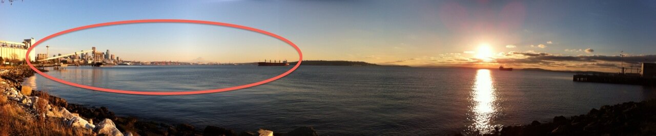
Yesterday I pulled off the bike trail to take a picture of the blindingly beautiful afternoon in Seattle: The mountain was out, the sun was setting in the west, and all looked pristine.  But upon closer inspection, a troubling band of brown air appeared hovering over Seattle and southward. The high pressure system locked in place above us is responsible for a lot of things: morning fog, pesky low clouds, and also degrading air quality. (KIRO’s Sam Argier explains “stagnant air” for you, here.)

The National Weather Service in Seattle has just extended its air stagnation advisory until this Friday at 4 p.m. (it was set to expire today at 7 p.m.):

AIR QUALITY…A PROLONGED PERIOD OF STAGNANT ATMOSPHERIC CONDITIONS WILL CONTINUE THIS WEEK. THIS WILL TRAP POLLUTANTS NEAR THE SURFACE AND CAUSE AIR QUALITY TO GRADUALLY DEGRADE AS LONG AS STAGNANT CONDITIONS PERSIST. […] PERSONS WITH RESPIRATORY ILLNESS SHOULD FOLLOW THEIR PHYSICIANS ADVICE FOR DEALING WITH HIGH LEVELS OF AIR POLLUTION.

Puget Sound Clean Air currently rates King and Kitsap county air at moderate, Pierce and Snohomish at unhealthy for sensitive groups. South of Seattle, Duwamish Valley and South Park have troubles with air quality year ’round, and this is just piling on. Most of Seattle proper is still within the Good range, with Beacon Hill claiming the best air.

Despite this, there is no burn ban in effect yet for King and Kitsap, though Pierce and Snohomish are at Stage One.

Where is our oxygen bar when we need it most?

Does Your Head Feel Squished Right Now?

Seattle’s atmospheric pressure was up to 30.79 inches at its peak around midnight last night, says KOMO’s Scott Sistek. Is that a big deal? It sure is. UW meteorologist Cliff Mass says the atmospheric pressure hasn’t gotten this high in the past 15 years in Seattle:

A very strong high pressure area is centered over the Northwest and southwest Canada, with pressures greater than 1040 hPa over much of the region and a 1046 hPa center over southern BC. 1046 hPa is equivalent to 30.89 inches of mercury.

UPDATE: History is made: “UW’s Neal Johnson ran the number and found that the sea level pressure at Seattle-Tacoma Airport was the highest since record keeping began there in 1948. ”

It’s very likely the heads of everyone you know will implode later today. Hairline cracks in the skull first, you know. Well, perhaps not. But Mass does say, “I wonder what this does to people with arthritis and sensitive joints.”

As someone who gets weather-related migraines, I can vouch for it feeling peculiar. Now, initially, full disclosure, I thought that it was due to the flight of Sazeracs I had last night at Canon (brandy, rye, and brandy + rye), but as the sensation has persisted, I realize it’s probably the pressure.

While we’re all feeling slightly smushed in the bell jar, anyone who lives along the “shoulders” of the pressure ridge is seeing pretty spectacular winds due to the pressure differential. One of Mass’s commenters points to this Los Angeles Times story about 100-mph winds. Some 300,000 Southern Californians were left without power.

Meanwhile, except for the threat of head-implosion, we’re sitting pretty, weather-wise: KOMO’s forecast calls for us to dry out over the next few days:

We will see an increase in clouds overnight and early Friday, but we’ll likely stay mainly dry.  Expect more sunshine tomorrow afternoon with highs in the mid 40s.

Saturday through next Tuesday will all be very similar weather-wise:  Areas of morning fog with a cold start, varying levels of afternoon sunshine, temperatures a few degrees cooler than normal.  Each day will also be rain-free.