Tag Archives: noaa

“What’s the Plan for Tsunami Debris?” You Ask

PACIFIC OCEAN (March 13, 2011) An aerial view of debris from an 8.9 magnitude earthquake and subsequent tsunami that struck northern Japan. The debris was inspected by a helicopter-based search and rescue team from the aircraft carrier USS Ronald Reagan (CVN 76). (U.S. Navy photo by Mass Communication Specialist 3rd Class Dylan McCord/Released)

Last week, a 150-foot Japanese fishing boat (outfitted for squid-fishing, to be precise) was spotting drifting, unmanned, about 150 nautical miles off B.C.’s Queen Charlotte Islands, and its arrival raised, more urgently, the question of what is to be done about the bulk of the debris when it arrives. (“Bulk” in abstract sense; the ocean will have had the chance to break up the debris into smaller and smaller pieces, scientists think.) Because not much is being done.

As Canada’s National Post reports: “Although authorities expect the ship to make landfall in 50 days, all it would take is one storm to send the vessel crashing into the coast before the week’s end. Nevertheless, there are no plans to intercept the ship.”

Why? Because offshore salvage is difficult and expensive, and it’s not clear yet how much the boat is worth (though you have to respect a boat that can sail itself across the ocean with no hands, and remain right-side up). If and until it becomes a significant hazard to navigation, or it is clear where it will wash up, there will be more watching and waiting. This is the dilemma in a nutshell when it comes to the larger governmental response to tsunami debris coming ashore.

On the U.S. side, Washington State Senator Maria Cantwell has been urging the government to bite the tsunami-debris bullet and act:

This discovery is further proof that the U.S. government needs a comprehensive plan for coordination and response to the tsunami debris. Coastal residents need to know who is in charge of tsunami debris response – and we need clearer answers now. Hundreds of thousands of jobs in Washington state depend on our healthy marine ecosystems. We can’t afford to wait until more tsunami debris washes ashore to understand its potential impact on Washington state’s 10.8 billion dollar coastal economy.

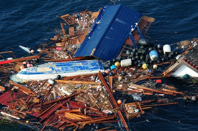
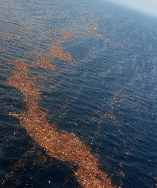
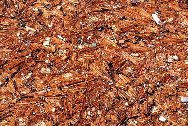
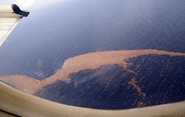
The March 2011 tsunami that hit Japan created an estimated 20 to 25 million tons of debris, a good deal of which was swept back into the ocean by the receding waters. Some of that sank, but some floated, and days later it could be seen in a huge debris field, heading out to deep ocean. After that, the debris dispersed enough so that it was no longer visible to satellite.

A year later, no one is sure precisely how much debris there is out there, whether or not it’s radioactive enough to worry about (unlikely), and what it will take to address the problem. In fine governmental form, the most common response seems to be to delay taking action as long as possible, in the hopes that it will become someone else’s problem. NOAA’s tsunami debris FAQ explains:

It’s hard to take emergency actions when there’s so little information about what we’re responding to – remember: it’s possible that most of the debris will break up, sink, or get caught up in existing garbage patches.

(Following on this, NOAA is also happy to explain to you why they’re not planning to do much about the garbage patches, either. Just in case you were going to ask.)

Perhaps not coincidentally, non-governmental estimates as to the arrival date of the debris have come with less runway. Ubiquitous oceanographer Curt Ebbesmeyer began reporting that the first wave of debris started showing up last October. On March 15, on his blog Beachcombers’ Alert, he wrote: “The identity of intermediate wind factor flotsam remains uncertain at this time. We suspect it will include overturned boats and the crowns of homes.” In a more recent Vancouver Sun interview, he mentioned that several more boats have been spotted already.

GOES-West Satellite’s Weather Imaging Goes South, Temporarily

See? Crap resolution. (Image: GOES-East/NASA)

NASA’s GOES-West weather satellite (aka GOES 15 aka GOES-P) normally sits in geostationary orbit, 22,300 miles up over the Pacific Ocean, halfway between Hawaii and the west coast of the U.S.

However, when an “incorrect plan” led to a “bad momentum unload” (which sounds like user error, not solar storm-related), the satellite automatically went into sun acquisition mode, and, while trying to orient itself, has stopped transmitting data.

The satellite has only been active in its eye-in-the-West-Coast-sky position since early December 2011, so it’s a bit early for it to be out of service, though there’s a GOES-14 sitting on the geostationary bench should anything catastrophic happen. And, in 2015, NASA will launch the first GOES-R series satellite, which “is expected to more than double the clarity of today’s GOES imagery and provide more atmospheric observations than current capabilities with more frequent images.”

NOAA has helpfully put GOES-East “in full disk mode while GOES-15 is out of service,” providing a larger field of view, but the angle “results in distorted images over the Northwest,” points out University of Washington meteorologist Cliff Mass, who also claims to have received word that the situation will be fixed by Friday.

As of Friday, by the way, KOMO weather shows us transitioning into a more normal 50s-and-rain spring pattern, so you may not care that your pictures of clouds are being updated every 30 minutes. But your TV weather people will be glad when GOES-West is back, and their forecast doesn’t look like it was generated by an Atari 5200.

Tsunami Debris Field Floating to West Coast Landfall (Photo Gallery)

110313-N-5503T-176
110313-N-SB672-368
110313-N-SB672-592
110314-N-3997W-062

110313-N-5503T-176 PACIFIC OCEAN (March 13, 2011) An aerial view of debris from an 8.9 magnitude earthquake and subsequent tsunami that struck northern Japan. The debris was inspected by a helicopter-based search and rescue team from the aircraft carrier USS Ronald Reagan (CVN 76). Ships and aircraft from the Ronald Reagan Carrier Strike Group are searching for survivors in the coastal waters near Sendai, Japan. (U.S. Navy photo by Mass Communication Specialist 3rd Class Alexander Tidd/Released)

110313-N-SB672-368 PACIFIC OCEAN (March 13, 2011) An aerial view of debris from an 8.9 magnitude earthquake and subsequent tsunami that struck northern Japan. The debris was inspected by a helicopter-based search and rescue team from the aircraft carrier USS Ronald Reagan (CVN 76). Ships and aircraft from the Ronald Reagan Carrier Strike Group are searching for survivors in the coastal waters near Sendai, Japan. (U.S. Navy photo by Mass Communication Specialist 3rd Class Dylan McCord/Released)

110313-N-SB672-592 PACIFIC OCEAN (March 13, 2011) An aerial view of debris from an 8.9 magnitude earthquake and subsequent tsunami that struck northern Japan. The debris was inspected by a helicopter-based search and rescue team from the aircraft carrier USS Ronald Reagan (CVN 76). Ships and aircraft from the Ronald Reagan Carrier Strike Group are searching for survivors in the coastal waters near Sendai, Japan. (U.S. Navy photo by Mass Communication Specialist 3rd Class Dylan McCord/Released)

110314-N-3997W-062 PACIFIC OCEAN (March 14, 2011) Debris float in the Pacific Ocean off the coast of Japan after a 9.0 magnitude earthquake and subsequent tsunami struck the nation on March 11. (U.S. Navy photo by Mass Communication Specialist Seaman Steve White/Released)

110313-N-5503T-176 thumbnail
110313-N-SB672-368 thumbnail
110313-N-SB672-592 thumbnail
110314-N-3997W-062 thumbnail

Something Sendai this way floats, and Sen. Maria Cantwell (D-WA) doesn’t want to wait until its projected 2014 arrival on West Coast shores to get ready for it. (Hawaii should see tsunami debris in 2013.) [SEE UPDATE AT END OF POST]

After the 9.0 earthquake hit Japan on March 11 of this year, the ensuing tsunami swept more than 200,000 houses (not to mention boats and cars) out to sea, where oceanographers predict they will make a slow journey to the West Coast, stopping off first at the Hawaiian Islands.

The massive sea-going debris field is said to measure 350 miles wide by 1,300 miles long, and to travel at ten miles per day. Eventually, some part of it will reach U.S. shores, and Cantwell would like to know how we are going to deal with it before then.

This week, Cantwell “introduced and secured passage of an amendment to address the threat approaching tsunami debris poses to industries up and down Washington’s coastline,” says the press release. The Senate Commerce Committee approved the amendment at a markup hearing, along with Cantwell’s Pacific Salmon Stronghold Conservation Act. (Also this week, Cantwell and Alaskan senators Lisa Murkowski and Mark Begich asked Senate Appropriations for funding to test for a deadly-to-salmon virus, rather than depending on Canadian test results alone.)

“We in the Washington economy depend on our waterways for a great deal of our commerce,” argued Cantwell. “We have everybody from workers at restaurants to tourist visitors that are all going to be impacted by this. We can’t wait until all of this tsunami trash washes ashore. We need to have an aggressive plan on how we’re going to deal with it.”

NOAA satellites tracked the debris field for about the first month after the tsunami, but as it dispersed in the water, they began to lose sight of it. However, the U.S. Navy’s 7th Fleet has caught up to a portion of it, with the largest agglomeration of debris reaching 69 miles in length.

No one really knows how much will reach the West Coast; a good deal of it is likely to join other ocean garbage, in the much larger debris field known as the”North Pacific Garbage Patch“–it’s a little sickening to note that as immense as the tsunami debris is, it’s a drop in the ocean compared to what ends up there because we have thrown it into the ocean. “Patch” is actually inaccurate two ways. It’s more of a plastic-particle soup, and so you can describe it as having various sizes depending upon what concentration of plastic particles you are comfortable with: If you are comfortable with not much at all, it’s about the size of Texas.

UPDATE: From KOMO TV/Seattlepi.com:

A local oceanographer says while the bulk of the debris will take several years to arrive, items that float could hit the Washington shore any day now.

“My message is the debris – big objects – could be here now,” said oceanographic detective Curt Ebbesmeyer. “Aircraft wings, boats, big buoys — big objects that catch the wind that can be here now.”

Coastal Radar On Time For September Start, Says Cantwell

Check out The Oregonian's coverage for more details.

Noting the extreme weather recently in tornado country, Sen. Maria Cantwell updated media on progress at Washington State’s new coastal Doppler radar installation in Grays Harbor County.

“I’m pleased that after several years of fighting for our state’s first coastal Doppler radar, we’re getting to the point where the foundation has been laid and the system is being implemented for an on-time opening this September,” Cantwell said. “The Pacific Northwest will be safer because of this technology which will help close the weather coverage gap.”

As you know from your TV, Western Washington has one other other Doppler radar installation, on Camano Island, but the Olympic Mountains make a better door than a window, and are constantly getting in the way. The precision of Doppler allows forecasters to tell if you’re going to be rained, snowed, or hailed on.

UW meteorologist Cliff Mass adds that another reason “we need the radar is that the offshore buoys are rapidly destroyed by winter storms,” providing a map with red Xs marking the spot of dead buoys. Anticipating the amount of work out at the Langley Hill Radar site between now and September, Mass has created a new site to track the installation’s progress.

People have been agitating for a coastal radar system since the late ’90s, but “the radar bureaucracy in Oklahoma was cool to the idea because we don’t get many thunderstorms,” Mass told The Oregonian.

As it turned out, we waited long enough to skip a radar generation, and this new installation will be one of the few weather radars in the country to use dual polarization, allowing meteorologists to “see” vertically as well as horizontally. Getting a full picture of air masses means it’s easier to tell how much precipitation they’re carrying.