Steve Malone, on Mount St. Helens with Scooter the seismo-dog
“The longer it’s been since the last earthquake,” said Steve Malone, brightly, “the sooner it is ’til the next one.” We were in his office at the University of Washington–he’s retired from full-time seismologizing, but still spends unpaid hours on campus answering questions from pesky bloggers, even if they’re fueled by sensationalist speculation about more frequent quakes.
He refocused my question away from end-time paranoia toward common sense acceptance: “We have several of these faults: there’s the Seattle Fault, and there’s one down in the Tacoma basin, one up at Everett and Whidbey Island…so if you say, we’ve got eight or ten of these faults, even if the earthquakes go once every thousand years, you sum them up, you could have something every few hundred years of some consequence,” explained Malone. “You don’t know, it could be 500 years, or it could be tomorrow.”
He also assured me that, incredible as it seems, it’s perfectly plausible that the recent Baja quake could have generated waves at a Ballard pool. “Large earthquakes generate big surface waves, and big surface waves generate a bit of a tilt as they go through. If a body of water’s natural free period happened to be the same as the frequency of those surface waves, then after a couple of cycles you might see it get built up enough,” said Malone. “The motions of surface waves can be on the order of centimeters. We just don’t feel it because it’s very slow.”
As an afterthought, he added: “The Denali quake of 2002–bigger than Baja [7.9] but further away–it generated a sloshing in Lake Union that damaged houseboats.”
And because I had to ask: “Tunnels aren’t usually an issue with earthquakes. The motion underground is less than on the surface, and they’re already built to withstand the pressures of everything else.”
As it turned out, we ended up talking across the breadth of Malone’s career, covering volcanic earthquakes, megathrust quakes, and the mysterious Episodic Tremor and Slip (ETS). His interest in seismology developed in graduate school; he’d studied physics as undergraduate, but was not “keen on modern physics” and gravitated toward geology, then seismology. At first he enjoyed the outdoors aspects of the work, “particularly in the volcano world,” but as his research progressed, he ended up in the office running computer models.
 Malone on Mount Rainier
“Since I retired I get to go out and play,” he said, smiling. “I volunteer for all sorts of fieldwork.” He’s been up on Mount Rainier working on an upgrade of instruments there, and out on the Olympic Peninsula conducting ETS studies in advance of the next appearance of the phenomenon.
“The ETS we have here are fairly regular, every 14 and a half months or so. The next one is scheduled–if you can call it that–for sometime mid-summer, maybe mid-August. We’ve got some experiments we’re planning to gear up and get extra equipment in the ground for. There’s some extra equipment out there now, running in background mode, but when the ETS arrives we’ll double the equipment, trying to look ever closer at it.”
The surprising result of my conversation with Malone was that I had my eyes opened to how much we still don’t know about the ground beneath our feet. On the one hand, theoretical explanatory power seems to have increased. For instance, Malone can detail easily how volcanic earthquakes are driven by “molten rock ascending through the crust to erupt–it has to break rock.”
“Whether earthquakes are due to these large-scale tectonic forces, plate motions, or whether they’re due to magma rising within the crust, it’s rock breaking,” emphasized Malone. “They look a little different on volcanoes, and usually you don’t have such big earthquakes–the faults, or weaknesses, are concentrated in the volcano itself, but in a few cases you can get moderate-sized earthquakes.” It’s the why of the rock-breaking that provides material for a lifetime of study.
As a student of Pacific Northwest volcanic history, he rolled his eyes a little at Iceland’s Eyjafjallajokull volcano. “Oceanic volcanoes are going off all the time, and Iceland is nothing more than an oceanic volcano which happens to be where the ocean is very shallow, like, non-existent. But it’s part of the oceanic rift system, which goes down through the Atlantic, more or less in the middle. We have one off our coast here, called the Juan de Fuca Ridge, 400 or 500 kilometers off our coast, same thing: There’s eruptions going on out there fairly frequently.”
For Malone, the big tectonophysics excitement centers on sneaky episodes of tremor and slip (ETS), which have only been discovered in the last ten years or so: “The slip is slow, it takes place over the course of days to weeks, rather than an earthquake. An earthquake takes place over the course of seconds, tens of seconds, maybe a few minutes for the really biggest.” Besides deformation in the ground, measurable via GPS, seismographic listening devices pick up an accompanying tremor that has scientists puzzled. What they do know is that slow or not, something major is going on.
The instances of ETS that the Pacific Northwest sees are mostly thanks to a major oceanic plate, the Juan de Fuca Plate, subducting under North America. Except, as Malone put it, “It’s stuck. It’s stuck along the Cascadia Fault Zone, which is just off our coast. Suddenly it’s going to let loose, and that’s when you get these megathrust earthquakes, magnitude 8 to 9 events.” In the meantime, if you put out GPS instruments around western Washington, you can watch them move toward the east or northeast–those on the coast more than inland, Malone told me, as the earth is compressed in the collision between plates.
But approximately every 14 months, your instruments will move back toward the ocean. “Maybe over the course of 14 months it moves four-and-a-half centimeters toward the northeast, but then it moves back again four or five millimeters over the course of a couple weeks,” said Malone.
What fascinates seismologists is that this kind of ETS event, in its slow-motion way, unleashes energy equivalent to a 6.5 magnitude quake or greater. It just does it with such nuance that no one noticed until recently. “During the height of one of these ETS events, you may have tremor going on for 24 hours a day,” Malone said. “It’s probably been going on for decades, centuries, but it’s only in the last decade, since about 1999, where it was for seen in Japan and reported in the literature, that we started looking for it here” (because of our subduction zone quirks*).
Earthquakes largely take place in the shallow part of the earth’s crust, “maybe the top 20 kilometers or so,” Malone explained. Generally, deeper than that, and the heat warms the rock too much for quake-producing stress to build up. The rock deforms–“not really flows, but sort of like silly putty,” Malone threw in. “But there are places–and a subduction zone is one of them–where the material that’s going down has not yet heated up that much. It can retain this brittle character down deeper.” The 2001 Nisqually quake‘s focus was just over 50 kilometers below the surface. So we get strangely deep quakes and strangely slow ones, too.
Capturing the slow movements of ETS requires the use of geodetic stations, which use GPS to measure the distances between stations to within a few millimeters over hundreds of kilometers. The University of Washington partners with Central Washington University for this part. “You put them in the ground and fix them in really solid so they’re only going to move when that part of the earth moves,” said Malone. “Then you remeasure them over months to many years, and you see deformation. You see the earth actually changing shape, at least that part.” For the upcoming ETS experience in August, Malone and his cohorts at Pacific Northwest Seismic Network are setting up what they call an Array of Arrays.
 Malone taking a measurement from a portable GPS device.
Currently they have 80 instruments (eight arrays with ten stations per array) placed over a one-kiometer area, which yields “pretty good” resolution of the tremor waves. But they plan to double their listening resolution to 20 stations this time around. The portable devices are about the size of a large beer can, Malone told me. “You can carry half dozen in your backpack.” They’re placed mostly on forest service land or private timber company land. While the ideal is flat topography, the researchers also have to avoid human habitation, which comes with all sorts of earth-shaking impacts of its own.
For non-scientists, the fascinating side of ETS may have more to do with its unclear relationship to megathrust earthquakes. Are they an early warning system? “They seem to be pretty independent,” said Malone, cautiously, noting that they haven’t had any significant earthquakes in the area since they began their close-up studies.
“We don’t know whether the ETS is taking away some of the energy build-up, or maybe it’s just concentrating it in a different place. Maybe you’re more likely to have a quake during an ETS period. But at the same time, earthquakes on the subduction zone will rip the whole thing, from northern California to southern British Columbia. And we only see the ETS– the one we’re looking at anyway–in this part.”
There are, in fact, other ETS events in Oregon and into northern California, but, Malone said, they seem to have a different schedule. “They don’t occur at the same time as ours, and their regularity may be different. It may be 11 months, or 22 months. If you look around, someplace on the subduction zone one of these ETS is going on at least half the time, if not more. So who’s to say it’s not the one in California that could trigger the megathrust earthquake, as opposed to ours.”
One of the reasons he’s fascinated by ETS, admitted Malone, is that he has seen seismic signals on volcanoes that are very similar to ETS. “It’s called volcanic tremor, and it’s a more or less continuous, low-level shaking that has to do with the motion of fluids within the volcano: maybe magma, maybe water, maybe steam, maybe gases. So the generation of tremor in volcanoes may be able to give us a clue or a hint. They’re really different–sometimes we call this non-volcanic tremor, but maybe there’s something about the mechanism that has similarities to volcanoes….”
Despite what CGI artists would have you believe, it’s still very hard to figure out what’s going on at-depth in the ground. Scientists are taking their best guess at what’s going with ETS, but I got the sense, talking with Malone, that if he could grab a magic shovel and dig his way down to a good viewpoint, he’d happily put in a few years.
“What we think ETS represents is actual slip on part of the locked zone,” he said. “It’s stuck, but some place between the seriously stuck part and that part which is much deeper, which is always slipping a little bit, somewhere in there, there must be a transition zone. And this transition zone is stuck a lot of the time, but then for a few weeks it slides, or at least part of it slides. That is the slow slip. It doesn’t take place like an earthquake–it doesn’t take place rapidly, KABOOM! It takes place over a period of many days, maybe as much as three weeks.
“We have some wild, arm-waving ideas [about tremor]. But they’re far from proven. Most of our speculation has to do with its very small–what we call low-stress-drop–slip.” I nodded, but seeing that it was more out of courtesy than understanding, Malone told me to visualize chalk screeching across a blackboard. “Even though you’re moving the chalk very slowly, it may still screech and generate a sound that you hear. Maybe that’s sort of what’s going on at depth. This is down at depths of 30 or 40 kilometers. It’s a long ways down, and we really don’t understand the nature of rocks, how they behave, under certain types of stresses. […] We’re pretty sure that fluids have something to do with it, too. Probably water, but water at these temperatures and pressures doesn’t really act like the water we drink up here.”
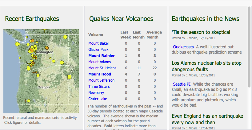
Right now, you can watch for ETS online, at PNSN’s interactive tremor map, and I can also recommend their Recent Quakes page. But don’t let the slow-motion stuff fool you. Big and small shakes are a way of life in the Northwest. Each year, over 1000 earthquakes with magnitude 1.0 or greater occur in Washington and Oregon, says PNSN’s site, which also shares this mind-bending factoid:
Vertical motion on the Seattle Fault and faults just to the north have caused the block of earth between faults H and I on the map to drop a total of more than 12,000 feet in the last 40 million years.
 Detail of the Viaduct
A megathrust quake is, as Malone reminded me, always one day closer to happening than it was yesterday. But despite the quake’s fearsome name, Seattle may, through our distance from the subduction zone, ride it out fairly well. Closer in, a different story: “For the coastal communities, the megathrust quake is a very big problem. Those people in those communities are going to suffer mightily. You get yourself shaken to pieces and then you get a big wave in your face.” The only good news is that we haven’t built major Northwest cities on the coast.
The central Puget Sound area, said Malone, can probably expect shaking not that much stronger than during the Nisqually quake. “It will go on a long time, and will have a different frequency content, so I expect the damage will be greater,” he clarified. “But people’s homes will likely do no worse than Nisqually–they’re small structures, moderately flexible.”
As for larger structures–the strongest shaking in Nisqually lasted only about 15 seconds. A megathrust quake may last two or three minutes. “The bridges, the skyscrapers, the stadiums, the big engineered structures like that, I worry about some,” admitted Malone, though he also pointed to the evidence provided by Chile that building codes make a huge difference.
If this hasn’t perturbed you yet, well, forget about the megathrust quake. Local surface faults also provide “the possibility of much bigger earthquakes than Nisqually,” mused Malone. “Nisqually was 50 kilometers deep, so even if you were directly over the source, you were still 50 kilometers away from the energy. But if you take that same earthquake, and moved it up to the top 15 kilometers, you’re talking about a huge difference in the amount of shaking.”
Got that earthquake kit together yet?
*More Malone on where you find ETS: “In Japan it turns out that ETS is only seen in southern Japan, not in northern Japan. The difference between those two is that northern Japan is where the Pacific plate is descending under Japan, the Asian plate. The Pacific plate there is very old and very cold, it’s come all the way across the Pacific, so it’s taken a long time getting there. For whatever reasons, that seems to be a difference than in southern Japan, the Philippine Sea plate–there’s a ridge down to the southeast of Japan that’s a spreading center–which is much, much younger, and as that plate goes under Japan, that’s where you see it currently. The same here–our subduction zone is very young, the ridge that’s generating the Oceanic plate is just off the coast. The rocks that are descending under us are only about 20 million years old, as compared to maybe 80 million years, after they’ve traveled all the way across the Pacific.
“There are some curiosities because there have been tremor bursts or periods of it–though it’s still not well documented–in Alaska. In Alaska, it’s the Pacific plate descending that is pretty old, not as old as in Japan, but still way older than here. Tremor has also been seen on the San Andreas Fault, but it’s very difficult to spot there–it’s quite weak and rare in comparison to these warm subduction zones. It’s taking place in only a few places that people have been able to detect it…barely: the central part of the San Andreas Fault, central California, an area called Parkfield. Even there it’s not occurring on the breaking part of the San Andreas, it’s occurring on the part of the San Andreas that’s really down deep, where it’s warmer. The earthquakes themselves don’t propagate that deep, but there must be some slippage going on, something between totally brittle and ductile deformation.”

 Before, the home page looked pretty much like this –>