Tag Archives: west coast

Tons of Japan’s Tsunami Debris Due on West Coast

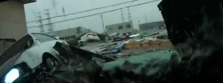
The afternoon of March 11, 2011, a 9.0 earthquake shook northeastern Japan. But the utter devastation came ten to thirty minutes later, when a tsunami struck with waves ranging from six to an unimaginable 128 feet high. Signs of human habitation–more that 200,000 homes–were simply erased from the landscape. Thousands and thousands of lives were lost.

Observers watched from helicopters in horror. On the ground, dashboard cams recorded the way the tsunami swept everything before it.

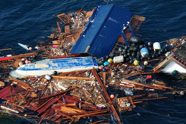
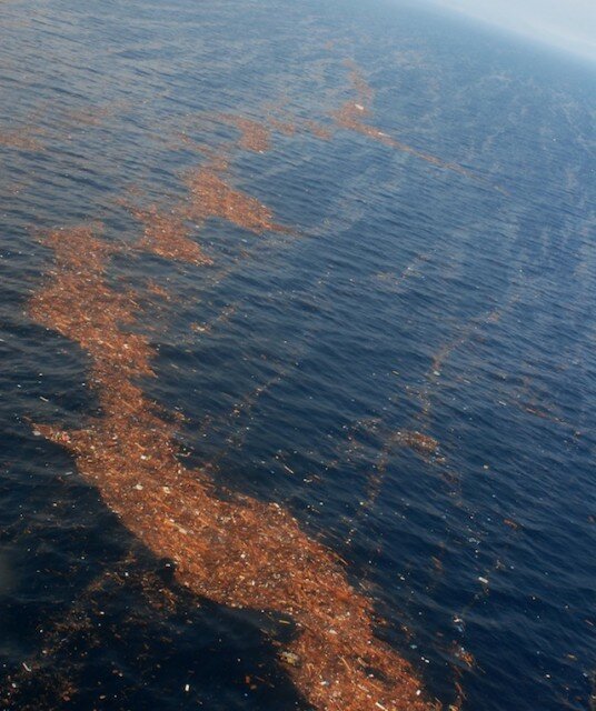
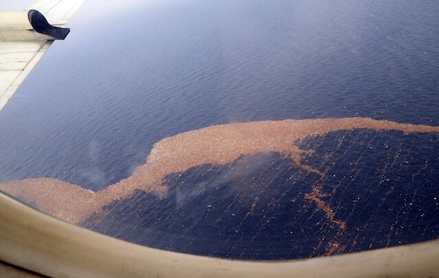
But what cameras have not, so far, been able to record is the tsunami debris once it left the coast of Japan. Shots of the debris field dwindled as the wreckage–estimated at millions of tons–reached open ocean. Much of that could have sunk. But now, “[t]he fate of the remaining 1.5 million tons is causing concern in communities from Alaska to California, amid warning that the trickle of debris arriving on US shores could soon turn into a deluge.”

Retired University of Washington oceanographer Curtis Ebbesmeyer says the sporadic sightings we’ve seen up to now–boats, plastic and styrofoam–were just the the tip of the tsunami trash-berg. “It’s unprecedented in recorded history,” he says. Not the tsunami part, obviously, but the ability to follow an event of this size from one side of the Pacific to the other. According to his latest run of OSCURS (Ocean Surface CURrent Simulator), the leading edge of a 2,000-mile-long train of debris is arriving on the West Coast…right about now.

Willapa Bay has already seen plenty of marine debris, as has Vancouver Island, though because of the looming specter of clean-up costs, no one is in an official hurry to distinguish tsunami debris from “regular” flotsam.

Ebbesmeyer says he suspects the major storm off the coast in mid-November may have speeded things back up, after debris progress slowed over the summer. It’s still not clear to anyone where, precisely, the debris will end up and in what quantity. As a guesstimate, Ebbesmeyer says, oceanographers have been supposing one-third might hit Hawaii, one-third get caught up in the Great Garbage Patch, and one-third journey on to the U.S. coast.

Then too, not all might stay, once it arrives. Flotsam can travel in a “great orbit” in the Pacific for decades, says Ebbesmeyer, recalling that in 2004, beachcombers found a WWII-era object.

The best analogy for the impacts of tsunami debris, explains Ebbesmeyer, is the 150-ton concrete-and-metal dock that washed up on the Oregon coast. More than 50 feet in length and about ten feet “tall,” less than a foot of it was visible in the water. Like the debris field, it was almost impossible to spot in open water, a hazard to marine navigation, and a Trojan horse of sorts: the dock was carrying more than 90 different, potentially invasive, species that were destroyed.

April 28 at “Ground zero,” Beach River, Montague Island (Photo: Gulf of Alaska Keeper/Chris Pallister)

Ebbesmeyer has also found kerosene containers (it’s popular in northeastern Japan to heat homes with kerosene), and there remains the small chance that something innocuous-looking could be “hot.” (Ebbesmeyer hopes for prudence’s sake that Geiger-counter sweeps of beaches by park rangers or police will become routine.)

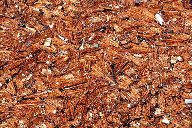
Mostly, he expects startling amounts of styrofoam–that makes up about 75 percent of marine debris. Marine birds will peck at it to see if it’s food and sea animals think the small pieces it breaks into are edible. But there’s no telling, really. Part of a house, “with most of the remains of a bathroom,” have already made the big float, he says. We’ll certainly see many more boats, parts of cars, fragments of houses.

But in terms of the clean-up, he’s optimistic. “Just give people the tools they need,” he advises, suggesting a massive-scaled “adopt-a-beach” program where people would be supplied with garbage sacks and trash-collecting tools, and given instructions on where temporary trash depots will be. He envisions a citizen’s beachcombing army ready to roll up their sleeves–and is even hopeful that they’ll aid in oceanographic research by reporting their findings at his Flotsametrics site.

“If you see something, say something,” in this case includes the date you saw it, a description and number of items, and possibly a photo. As a researcher, Ebbesmeyer was delighted at the prospect of camera-phone photos with embedded GPS data coming in. Of course, NOAA would like you to cc: them on debris reports as well. “If you see small debris, like bottles, aluminum, or Styrofoam, remove the debris from the beach and recycle as much as possible,” they say. For anything that looks hazardous, in Washington call 1-855-WACOAST (1-855-922-6278).

“What’s the Plan for Tsunami Debris?” You Ask

PACIFIC OCEAN (March 13, 2011) An aerial view of debris from an 8.9 magnitude earthquake and subsequent tsunami that struck northern Japan. The debris was inspected by a helicopter-based search and rescue team from the aircraft carrier USS Ronald Reagan (CVN 76). (U.S. Navy photo by Mass Communication Specialist 3rd Class Dylan McCord/Released)

Last week, a 150-foot Japanese fishing boat (outfitted for squid-fishing, to be precise) was spotting drifting, unmanned, about 150 nautical miles off B.C.’s Queen Charlotte Islands, and its arrival raised, more urgently, the question of what is to be done about the bulk of the debris when it arrives. (“Bulk” in abstract sense; the ocean will have had the chance to break up the debris into smaller and smaller pieces, scientists think.) Because not much is being done.

As Canada’s National Post reports: “Although authorities expect the ship to make landfall in 50 days, all it would take is one storm to send the vessel crashing into the coast before the week’s end. Nevertheless, there are no plans to intercept the ship.”

Why? Because offshore salvage is difficult and expensive, and it’s not clear yet how much the boat is worth (though you have to respect a boat that can sail itself across the ocean with no hands, and remain right-side up). If and until it becomes a significant hazard to navigation, or it is clear where it will wash up, there will be more watching and waiting. This is the dilemma in a nutshell when it comes to the larger governmental response to tsunami debris coming ashore.

On the U.S. side, Washington State Senator Maria Cantwell has been urging the government to bite the tsunami-debris bullet and act:

This discovery is further proof that the U.S. government needs a comprehensive plan for coordination and response to the tsunami debris. Coastal residents need to know who is in charge of tsunami debris response – and we need clearer answers now. Hundreds of thousands of jobs in Washington state depend on our healthy marine ecosystems. We can’t afford to wait until more tsunami debris washes ashore to understand its potential impact on Washington state’s 10.8 billion dollar coastal economy.

The March 2011 tsunami that hit Japan created an estimated 20 to 25 million tons of debris, a good deal of which was swept back into the ocean by the receding waters. Some of that sank, but some floated, and days later it could be seen in a huge debris field, heading out to deep ocean. After that, the debris dispersed enough so that it was no longer visible to satellite.

A year later, no one is sure precisely how much debris there is out there, whether or not it’s radioactive enough to worry about (unlikely), and what it will take to address the problem. In fine governmental form, the most common response seems to be to delay taking action as long as possible, in the hopes that it will become someone else’s problem. NOAA’s tsunami debris FAQ explains:

It’s hard to take emergency actions when there’s so little information about what we’re responding to – remember: it’s possible that most of the debris will break up, sink, or get caught up in existing garbage patches.

(Following on this, NOAA is also happy to explain to you why they’re not planning to do much about the garbage patches, either. Just in case you were going to ask.)

Perhaps not coincidentally, non-governmental estimates as to the arrival date of the debris have come with less runway. Ubiquitous oceanographer Curt Ebbesmeyer began reporting that the first wave of debris started showing up last October. On March 15, on his blog Beachcombers’ Alert, he wrote: “The identity of intermediate wind factor flotsam remains uncertain at this time. We suspect it will include overturned boats and the crowns of homes.” In a more recent Vancouver Sun interview, he mentioned that several more boats have been spotted already.

Tsunami Debris Field Floating to West Coast Landfall (Photo Gallery)

110313-N-5503T-176
110313-N-SB672-368
110313-N-SB672-592
110314-N-3997W-062

110313-N-5503T-176 PACIFIC OCEAN (March 13, 2011) An aerial view of debris from an 8.9 magnitude earthquake and subsequent tsunami that struck northern Japan. The debris was inspected by a helicopter-based search and rescue team from the aircraft carrier USS Ronald Reagan (CVN 76). Ships and aircraft from the Ronald Reagan Carrier Strike Group are searching for survivors in the coastal waters near Sendai, Japan. (U.S. Navy photo by Mass Communication Specialist 3rd Class Alexander Tidd/Released)

110313-N-SB672-368 PACIFIC OCEAN (March 13, 2011) An aerial view of debris from an 8.9 magnitude earthquake and subsequent tsunami that struck northern Japan. The debris was inspected by a helicopter-based search and rescue team from the aircraft carrier USS Ronald Reagan (CVN 76). Ships and aircraft from the Ronald Reagan Carrier Strike Group are searching for survivors in the coastal waters near Sendai, Japan. (U.S. Navy photo by Mass Communication Specialist 3rd Class Dylan McCord/Released)

110313-N-SB672-592 PACIFIC OCEAN (March 13, 2011) An aerial view of debris from an 8.9 magnitude earthquake and subsequent tsunami that struck northern Japan. The debris was inspected by a helicopter-based search and rescue team from the aircraft carrier USS Ronald Reagan (CVN 76). Ships and aircraft from the Ronald Reagan Carrier Strike Group are searching for survivors in the coastal waters near Sendai, Japan. (U.S. Navy photo by Mass Communication Specialist 3rd Class Dylan McCord/Released)

110314-N-3997W-062 PACIFIC OCEAN (March 14, 2011) Debris float in the Pacific Ocean off the coast of Japan after a 9.0 magnitude earthquake and subsequent tsunami struck the nation on March 11. (U.S. Navy photo by Mass Communication Specialist Seaman Steve White/Released)

110313-N-5503T-176 thumbnail
110313-N-SB672-368 thumbnail
110313-N-SB672-592 thumbnail
110314-N-3997W-062 thumbnail

Something Sendai this way floats, and Sen. Maria Cantwell (D-WA) doesn’t want to wait until its projected 2014 arrival on West Coast shores to get ready for it. (Hawaii should see tsunami debris in 2013.) [SEE UPDATE AT END OF POST]

After the 9.0 earthquake hit Japan on March 11 of this year, the ensuing tsunami swept more than 200,000 houses (not to mention boats and cars) out to sea, where oceanographers predict they will make a slow journey to the West Coast, stopping off first at the Hawaiian Islands.

The massive sea-going debris field is said to measure 350 miles wide by 1,300 miles long, and to travel at ten miles per day. Eventually, some part of it will reach U.S. shores, and Cantwell would like to know how we are going to deal with it before then.

This week, Cantwell “introduced and secured passage of an amendment to address the threat approaching tsunami debris poses to industries up and down Washington’s coastline,” says the press release. The Senate Commerce Committee approved the amendment at a markup hearing, along with Cantwell’s Pacific Salmon Stronghold Conservation Act. (Also this week, Cantwell and Alaskan senators Lisa Murkowski and Mark Begich asked Senate Appropriations for funding to test for a deadly-to-salmon virus, rather than depending on Canadian test results alone.)

“We in the Washington economy depend on our waterways for a great deal of our commerce,” argued Cantwell. “We have everybody from workers at restaurants to tourist visitors that are all going to be impacted by this. We can’t wait until all of this tsunami trash washes ashore. We need to have an aggressive plan on how we’re going to deal with it.”

NOAA satellites tracked the debris field for about the first month after the tsunami, but as it dispersed in the water, they began to lose sight of it. However, the U.S. Navy’s 7th Fleet has caught up to a portion of it, with the largest agglomeration of debris reaching 69 miles in length.

No one really knows how much will reach the West Coast; a good deal of it is likely to join other ocean garbage, in the much larger debris field known as the”North Pacific Garbage Patch“–it’s a little sickening to note that as immense as the tsunami debris is, it’s a drop in the ocean compared to what ends up there because we have thrown it into the ocean. “Patch” is actually inaccurate two ways. It’s more of a plastic-particle soup, and so you can describe it as having various sizes depending upon what concentration of plastic particles you are comfortable with: If you are comfortable with not much at all, it’s about the size of Texas.

UPDATE: From KOMO TV/Seattlepi.com:

A local oceanographer says while the bulk of the debris will take several years to arrive, items that float could hit the Washington shore any day now.

“My message is the debris – big objects – could be here now,” said oceanographic detective Curt Ebbesmeyer. “Aircraft wings, boats, big buoys — big objects that catch the wind that can be here now.”