
 List
List Map
Map Category
 Date
Date Popularity
 Tags
Tags
Our Whidbey Island correspondent provides this winter wonderland view, confirming this Seattlepi.com story, "Whidbey Island faces snow days." Islanders are expecting between "1 and 3 inches of snow" to accumulate today, with perhaps another inch coming Thursday.
Here in Seattle, roadways are mostly bare and wet--after graupel yesterday and some wet snow for the commute home, we're in a snow shadow cast by the Olympics. In this morning's post, the UW's Cliff Mass suggests that while snow is on the way, at least today it won't be cold enough to freeze during the afternoon commute:
The models indicate that during the day the flow approaching the region will weaken and turn more southerly....that will open Seattle to snow showers, and as the low moves south, northerly flow will push southward. But not yet. Last night the NWS was going for a hard freeze of this stuff later today during the commute home. Looking at the situation now I believe that is highly unlikely....
(more)

Last Friday, the UW's Cliff Mass was running the models and snow kept popping up: "The model forecasts for next Wednesday and Thursday would warm the heart of a polar bear. You want a high amplitude trough, well positioned to bring in cold air...you got it."
But the models have forecast snow before, and the key elements have skittered around enough in the intervening days that nothing much has appeared. "I won't get too excited about this until Monday," wrote Mass.
Now it's Monday, and KOMO's Scott Sistek sounds pretty confident in flakes for the week ahead: "Snow chances begin as early as Monday night, but low elevation areas don't really have potential to see any accumulations until at least Tuesday or Wednesday."
Tuesday there'll likely be a convergence zone playing impishly with where winter weather appears in force, but, says Sistek, "Wednesday midday through Thursday morning is our best chance of lowland snow of the week, with greatest chances for getting snow and accumulations north of Seattle." Here's the updated National Weather Service forecast for the week, also picking on Wednesday as a good snow day: ...
Regular readers will know that besides being the region's ne plus ultra weather geek, UW meteorologist Cliff Mass takes a keen interest in our state's math performance. A few years ago, he and others went to court against the adoption of the Discovery Math series--and got a King County Superior Court judge to agree.
Now Mass is holding forth on his blog about a move to scrap "A-rated State math standards" in favor of a national set, Common Core State Standards, that Mass says just don't measure up:
What do our state education bureaucrats want to replace our new math standards with? Recently drafted, untested, and poorly written Common Core standards developed by a group sponsored by the National Governor's Association. These standards are also being pushed by the Gates Foundation and Obama's Secretary of Education, and about 40 states have signed on (some of whom are having second thoughts!).
Mass isn't the only one critical of Common Core, but regardless of where you stand on the content, the cost of adoption might bring you up short: "OSPI has estimated (in the report they submitted last week--a month after required by law!) that the switch to Core math and language standards would cost $192 million dollars...which I suspect is low," writes Mass. In December's special session, $51 million was cut from higher education, so a hundred million or two makes a big difference.
The Seattle branch of the National Weather Service (now on Facebook) was making dire predictions of a snow storm to arrive this week, but has since backed off the gas pedal, so far as accumulations go. Paul Deanno at KOMO is calling for two to four inches of snow to fall tomorrow afternoon, but that should get washed away overnight, as snow changes to rain.
Here's the revised, elliptical NWS prediction as of 9:20 a.m.:
THE NEXT...MUCH ANTICIPATED EVENT IS STILL UNFOLDING. WARM FRONTAL PRECIP WILL SPREAD NORTH INTO W WA TUE EVENING WHICH WILL LIKELY START OUT AS SNOW. NAILING THE SNOW TOTALS IS RATHER DIFFICULT AS WARMER AIR WILL CHANGE THE PRECIP TYPE OVER TO RAIN...SOMETIME LATE TUE NIGHT OR EARLY WED MORNING. THIS OUGHT TO MELT ANY ACCUMULATIONS. UNTIL THEN...MAY SEE WINTER WEATHER ADVISORY AMOUNTS IN THE LOWLANDS...
UW meteorologist Cliff Mass had been hoping for an historic snow event, but over the weekend, his hopes faded as models kept showing warmer air heading north, rather than south of us. (All we need is for that to change, and we're back in snowdrift country.) Now he's talking winds and heavy rains, none of which will help the condition of our streets. Look for that record number of potholes to increase.

Hopefully you're not planning on going anywhere the next few days. As CHS reminds you, King County Metro is providing reduced service all this week, before they jack you for an additional quarter at the fare box beginning next week. Here's their holiday bus service notice. So whether or not it snows and sticks mid-week, there's a good chance you'll be standing around in the cold for longer than usual, waiting for a bus to show.
Regarding that chance of snow, the National Weather Service has released this statement:
THERE IS A CHANCE OF HIT AND MISS LOWLAND SNOW FROM LATE TUESDAY NIGHT INTO THURSDAY MORNING. A DEEP UPPER TROUGH WILL SETTLE OVER WESTERN WASHINGTON BRINGING WITH IT COLDER TEMPERATURES AND SOME PRECIPITATION.
(Millions of dollars in sophisticated weather modeling equipment and they can't figure out how to work the Caps Lock key.) Be sure to check in again Tuesday morning to see how the NWS Seattle forecast is firming up. For now, they're claiming the precipitation will be "showery," which means it's more or less impossible to tell exactly which area might get how much snow. ...
 Why can't we handle snow? Let's start with why we can't read. Or why we choose to drive down the steepest, iciest hills in Seattle.
UW meteorologist Cliff Mass has a new post up promising "Perspective on the Winter So Far." Here's the conclusion, which may surprise some of you who believe the end-times are near:
Has this early winter been wacky and unusual? Not particularly. Pretty much every year there are storms and floods and daily records. Sign of global warming? No reason to think so.
Mass ticks off precipitation, temperature (average, highs and lows), snow pack, La Niña--it all averages out to be fairly normal. That doesn't mean nothing of note has happened; I think Mass's larger point is that winters, whether light or heavy, tend to bring us remarkable weather for the simple fact that people like to remark upon the weather doing something.
(On global warming, Mass always tries to direct people's attention away from weather to climate. Weather is statistically noisy.)
What I notice about recent winter weather is not the weather so much as our seeming inability to respond to any winter at all. A quick review of weather records reveals that the truly whopper snow storms and deep freezes dwarf anything I've seen the past 20 years. When we talk about terrible Seattle winters now, what we are really talking about is failures of our infrastructure, and the fact that few of us are even remotely prepared to go a few hours without power, heat, and access to transportation.
"Why can't we handle snow?" asked the Seattle Times, in the wake of our late-November few inches. People were "trapped" on I-5 for up to ten hours. Psychologically, that's more than long enough for people to lose their minds. Drivers ran out of gas, they had little food or water with them, and once gridlock set in, there was nowhere to go--not forward, not backward....

"Talking about rain... a LOT is coming starting Sunday, with the establishment of a significant pineapple express event," says UW meteorologist Cliff Mass. "And a super warm front." [UPDATE: "Atmospheric River."] His post is mainly about the squall line that blew through Wednesday morning, drenching the city, but the National Weather Service goes into a bit more detail.
From Saturday night through Monday, we should be experiencing a pineapple express weather system, which besides dumping a lot of rain on us, will raise the snow level to 7,000 feet--adding some snow melt to the rain-swollen rivers in the area. It's not clear yet from the models where the intensity of the rains will be strongest, so stay tuned.
KOMO's Paul Deanno says it could be the wettest storm in two years, adding that "if the rain goes for 24 hours or longer, we'll probably be dealing with flooding on the Nooksack, Skagit, Stillaguamish, Snoqualmie, Satsop and Bogachiel Rivers. If the rain keeps going, even the more stubborn-to-flood rivers like the Chehalis and Cowlitz could go over their banks." On the bright side, the NWS advises that the flood risk for the Green River is minimal.
 We're headed for a "very wet Monday afternoon" says KING 5's Rich Marriott, as a storm blows in with wind and rain. Up in the mountains that means snow, and if you're planning on a trip through the passes, consult with WSDOT first. Higher elevations are expected to get some six to twelve inches of snow from this storm.
Speaking of the weather, Cliff Mass is excited about two new ways you have to track weather online. There's a radar aggregator the UW has cooked up (that's where the screenshot comes from), and the kids in atmospherics have put together WINDWATCH, which...well, the name is fairly self-explanatory.
It's also timely, since this storm is expected to bring high winds just north of Seattle, and you can see what the models predict. Looks like the worst of it is supposed to come around 10 p.m. this evening.
 Our Flickr pool's shawnmebo is already back with snow day shots! That's fast!
UW meteorologist Cliff Mass has been putting out updates fast and furiously regarding the snow forecast for today, which is changing hourly as snow accumulates. Now he's concerned about "serious snow."
His latest post (titled "Humility") says we're pretty much guaranteed "2-4 inches south of the city, with roughly 1-2 inches on the north side. More as you head towards the Cascades and south." (Let's go to the radar!)
But looking at the way things are setting up, that might not be the worst in store:
The 11 AM surface map...just available shows a 1002-mb low over the NW tip of the Olympic Peninsula and the latest visible image show VERY unstable air offshore. If the low goes south of us and draws some of that cold, unstable air in...and it meets the cold stream from the north, we are talking about serious snow (6-12 inches).
Mass was earlier led astray by models which had the low farther south of Seattle, bringing us a blast of cold air but not much in the way of snow. ("Clearly, this was not a great success for the models--clearly more is getting farther north than forecast this morning.")
Might as well head home and fire up the hot chocolate, and wait to see what transpires.
 Radar map image courtesy of the National Weather Service
As of Saturday, the UW's Cliff Mass was downgrading the risk of flooding even over the Olympics and North Cascades, because models were showing the rains passing through today, rather than setting up camp and pouring for several days.
That said, today's downpour is already well underway, and Seattle traffic maps are a motley of red and black. UW's Probcast gives us a 15 percent chance of more than an inch of rainfall (maximum 1.4 inches).
The massive low that's delivering this moisture is parked up in the Gulf of Alaska, and generating 30- to 40-foot waves out to sea.
That low is weakening, and tomorrow there's only a ten percent chance of rain. Again, looking out the window, that's a little hard to believe--but science says so. If you haven't voted, you won't be able to blame lousy weather for your lack of civic responsibility.
 Storm-watchers will be packing up and heading to the north coast this weekend, as a major low may bump right into us on Sunday. It's "what we call an extratropical cyclone in the business," reports Cliff Mass, with barely disguised anticipation.
You can watch an animated model here, but the short story is that if conditions are right (or wrong, depending on your perspective), the coast will get hit with sustained winds up to 45 knots, with 30- to 40-foot waves. That would likely bring power outages from downed trees and tree limbs, and attempts by surfers with poor risk/reward estimation to hit the beach.
Meanwhile, inland, all we get is a pretty good chance of showers on Saturday, increasing on Sunday. Mass explains why it doesn't look like we'll get in on the action:
I should note a rule of thumb of local meteorologists: to get strong winds over Puget Sound and the southern interior the low pressure center must cross the coast south of central Vancouver Island (my book has more on this).
 Artist's rendering of Chihuly exhibit at Seattle Center
This is a wise decision, since their conclusion that visual arts are underrepresented on Seattle Center campus--ergo, the Chihuly exhibit wins--immediately raises questions about the Center's dogsled-racing, amateur-yodeling, and unicorn-riding gaps. I don't think anyone would argue that the works of Dale Chihuly are underrepresented in Seattle as a whole, and certainly not in places where people tend to go to see visual art, like, say, museums.
The wonderful thing about this bemusingly circular process is that these eight citizens armed with the truth are all members of the Center's Century 21 Committee. When we rely on their judgment that the Chihuly exhibit represents the best financial resource for the Center--which is a debatable top priority--let's keep in mind that these are the same people who drafted the Center's largely unfunded 20-year master plan to begin with. Here is a graph that illustrates their credibility.
Other things that happened in Seattle this week include the Storm returning victorious, the Columbia Center's mother of all re-fis, the sound of Boeing planning new hires, and Seattle Schools telling a blogger who's often the only person covering their press events (okay, besides West Seattle Blog) that she couldn't ask them questions. (You certainly shouldn't ask about class size, and don't even bring up Garfield H.S.) Fnarf weighed in on the waterfront, and a panel suggested cyclists belong in the back of the ferry.
Also, here's a great post from Cliff Mass on why my phone says it's overcast and rainy when all I can see are blue skies....

Mayor McGinn announced that he'd talked the unions representing city employees into letting go of their two-percent COLA; instead they get 0.6 percent. The city's projected deficit for 2010-12 has grown by $11 million, to $67 million, since April. That kind of pressure has led the city to blackmailpressure MOHAI into giving up relocation funds won from the state, with MOHAI reaching DEFCON 1 ("We'll close, we swear it!") in short order.
Boeing got local-source religion. Microsoft worked on cementing their image as the Evil Empire. Amazon may have leaked Office for Mac 2011's ship date. Starbucks decided drive-through customers were really thirsty.
Cliff Mass says the only question is how strong our La Niña winter will be--cold and wet, or colder and snowier. While the Howard Hanson Dam situation has improved, "Now is not the time to relax," says King County Council's Julia Patterson. Wet weather isn't good news for residents of Redmond's mold-infested Riverwalk condos, but stay tuned--I hear the cavalry may be coming.
Around the neighborhoods, Capitol Hill residents learned they have deer and a start-up incubator. TechFlash took a tour of Belltown's PopCap Games. Eastlake's Floating Homes tour is Sunday, Sept. 12. "Seattle’s Landmarks Preservation Board voted to nominate the community-center building and steam plant at the 580-unit Yesler Terrace public-housing project for landmark designation."...
Our Flickr pool's got grillin' fish in it, thanks to Great_Beyond.
A weekend in the '90s? Unpossible! But the thermometer and Cliff Mass say it's so. Speaking of Cliff, here he is losing his mind at the absence of clouds along the Washington coast. It's a picture, so it happened.
Okay, let's keep this short because we all have better things to do. We can all pat ourselves on our green backs because Seattle made it into the NRDC's list of the top 22 cities who are "beacons on energy innovation." City Light's wind and hydropower initiatives helped, but so did an ambitious weatherization plan.
Maria Cantwell was down at the Port of Tacoma yesterday talking about her FREIGHT Act. Dino Rossi was making spurious claims about medical research. What else? Mars Hill bought a church in the U District (god not included). Microsoft's Xbox is selling like hot pixelcakes, says TechFlash. HorsesAss noticed the Seattle Times' questionable tax-math skills, too.
Meanwhile, we've got hoods in the 'hoods. CHS has the new about the armed hold-up at 14th and Republican last night, as well as two coffee shop break-ins. This is probably why Obama is visiting the East Precinct. Belltown=Founders Day Festival. RVP offers a little counter-commentary on the Belltown public safety push. CD News welcomes Hollow Earth Radio. Southend Seattle welcomes Seward Park bats. On Queen Anne, "affordable" studio apartments are priced at $1,105 per month (for this the developer gets a tax reduction of $400,000)....
It was the best of times, it was the worst of times, it was the grand opening party for the Hard Rock Seattle three months after the fact. Look guys, if you wanna have a party, have a party, but there’s really no reason to term it a "grand opening" event that late. There's also no need to schedule it so that it conflicts with SIFF's opening night, but that is another story.
Regardless, HRC knows how to throw a bash. Four words: open bar all night. Not to mention the huge spread of food, the mass guitar smash featuring local luminaries like Steve Pool and Sir Mix-A-Lot, and high energy performances by Ra Ra Riot and The Thermals. (Thanks to Jeff for the vid.)
 NOAA photo of NEXRAD installation
Our coastal radar system will be installed a year early, announced U.S. Senator Maria Cantwell yesterday. Chair of the Senate Oceans, Atmosphere, Fisheries, and Coast Guard Subcommittee, Cantwell had secured the millions of dollars necessary to build a new system, but this WSR-88D NEXRAD radar is coming to us from the Keesler Air Force Base in Mississippi. Apparently they weren't using it, and it was just sitting there.
"Although Washington bears the brunt of wintertime Pacific storms, our weather radar coverage has been shockingly inadequate, putting lives and property at risk," said Senator Cantwell in her announcement. "By acquiring this new radar technology and positioning the system west of the Cascades, Washingtonians can better prepare for the impact of the big Pacific storms on businesses and homes."
The radar will be sited out near Grays Harbor, with the site finalists announced this June.
"The top location is Langley Hill, located northwest of Hoquiam and about 3.5 miles east of Copalis Beach," writes University of Washington meteorologist Cliff Mass, a big proponent of coastal radar. He's especially pleased about the fact that it's a dual-polarization (polarimetric) radar that "sees" vertically and horizontally, which "allows identification of precipitation type and better estimation of rainfall intensity."
Mass expects weather forecasting in our area to make a major leap in accuracy once the radar is operational, as we'll have a much better view of Pacific storms heading our way, before they even make landfall.

First of all, if you're feeling a little out of sorts with the weather, it's not just you. And you can tell the "It's spring in Seattle, stupid, it's always like this" crowd that that's not true either. Cliff Mass has done the numbers and "For the past ten days the maximum temperature has stayed well below normal."
That said, buckle up, because there's more wet on the way. Tonight and tomorrow should bring a good soaking, we get Thursday off, and then Friday another storm seems to be shaping up that could bring strong winds as well as rain. I'll keep an eye on Cliff's blog and report back when he updates closer to the weekend. In the meantime, keep the galoshes handy, and be prepared to sprint outside on Thursday for sunbreaks.
Trans Alta's Centralia electricity-generating coal plant, our local Smaug the dragon, is the state's top CO2 emitter, pumping out 11 percent of the state's total emissions. It's also tops in mercury and nitrogen oxide. And despite gas-powered plants increasing the power of our electric blanket, the state, led by Governor Gregoire, isn't pushing to quickly decommission the plant or up its scrubbing power. "How's that hopey, changey thing workin' out for ya?"
If Cliff Mass is right about another cold trough heading our way, we'll still be running our electric heaters in late May. If we still live indoors. Nationally, more of the safest mortgage holders were losing their homes to foreclosure (almost 40 percent of new foreclosures in Q1), while in Seattle, home depreciation is expected to continue through this year. That might sound grim, but what it means, graphs the Seattle Bubble, is that home prices are coming back into line with median income.
TechFlash reports that six months after their marriage, Amazon and Zappos are still using separate bank accounts. Nordstrom is doing so well, they increased their dividend. "If MSFT is a patent alley thug, then SFDC is a crack addict cat burglar." Starbucks is doing so well, they spent $180,000 in Q1 on lobbying. The Port of Seattle seems to be weathering the economic doldrums pretty well....

The National Weather Service has a wind advisory out for the Seattle area, in effect from 1 p.m. today until midnight:
LIGHT NORTHEAST WINDS ACROSS THE REGION THIS MORNING WILL SHIFT TO SOUTHERLY MIDDAY AND RISE QUICKLY DURING THE EARLY AFTERNOON...WITH LOCAL WINDS OF 30 MPH AND GUSTS TO 45 MPH CONTINUING THROUGH LATE EVENING. THE WINDS WILL EASE AFTER MIDNIGHT.
It's a little disconcerting, the all-caps format from the NWS, isn't it? You can almost hear the Telex chattering as they stare into a monochrome CRT monitor. Anyway, expect wind, cooling temperatures, and some rain in your face as the afternoon progresses.
Cliff Mass has been watching this storm's development--it's primarily aimed at the coast, and models show an even stronger storm on the way than forecasted yesterday:
Here is the latest forecast for 5 PM tonight...pretty amazing. 989 mb low and a huge pressure gradient to its south and southeast. The simulation indicates even stronger winds than last night, with areas immediately offshore experiencing 60 kt sustained winds and hurricane-force gusts.
Yesterday he explained the wind-generating dynamics. While the low moving in doesn't pack the punch of a winter storm, our springtime "environmental pressure" is high, so there's a big differential between the two air masses. That, friends, means wind with a capital W! The coast will most likely see power outages--and we could see local outages, too, from small trees or big branches.
Hurrricane Ridge's web cam view
A few days ago, I rang up Seattle City Light to see if the winter storm pummeling the Olympics and Cascades was doing anything to replenish our snowpack--and hopefully keep the hydropower running strong this summer. The upshot was, we were going to need more than one storm.
Well, buckle up. Cliff Mass's post is titled "Stunning Day of Convection and BIG Storm Coming."
Major weather changes are in store Friday and Saturday. Moderate to heavy precipitation over the region...with a very strong low moving just north of us. Winds will be very strong over the coast (40-60 kts), northwest Washington (30-50 kt) and breezy (20-40 kt) over the PS lowlands on Friday.
The National Weather Service has Seattle under a High Wind Watch for most of Friday; they say gusts might hit 55 mph over western Washington, and if that's the case, we can count on some power outages as trees and tree branches take down power lines.
ProbCast also has our daytime chance of precipitation at 85 percent, so it sounds like Friday should be quite a day. Raincoats, yes. Umbrellas, not so much.
Courtesy of KIRO TV's Wildside, Summit West web cam.
I have two $90-plus electric bills this month, one for the office, one for the home--a 13.8 percent rate increase went into effect this January--so my inner Scotsman danced a jig on reading Cliff Mass's weather report on our blustery weather:This is exactly the kind of pattern that lays down lots of snow. Below is the forecast 24-h snow amounts ending 5 AM Tuesday morning...some locations get well over a foot. City Light should think about revoking their electricity surcharge.
Mass is probably being a little facetious there, but I spoke with City Light's Scott Thomsen about it anyway. You never know when you might learn something. Besides, Crystal got 26 inches the last 48 hours. That's not nothing.
Earlier this month, Seattle City Light announced that thanks to an anemic snowpack (the lowest in 20 years), the amount of hydropower they could generate would likely be limited. With no "extra" power to sell, they were forecasting a loss in revenue of $70 million. On March 22, the City Council approved a 4.5 percent rate increase, to go into a rate stabilization account.
The rate stabilization account, claiming $2 extra per "average" customer per month, is supposed to create a $100 million fund that Seattle City Light can use to combat volatility, either in power costs or in snowpack. Once the account reaches $100 million, the surcharge goes away....
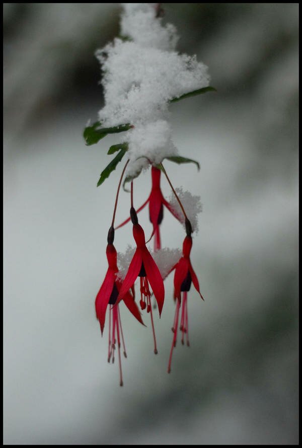
 A late February snow from 2009.
Some cold and wet is sneaking past our nice El Niño pre-spring this week. Cliff Mass says it'll bring snow in the mountains by tonight and through the early part of the week. Depending upon the mysterious workings of our Puget Sound convergence zone, lowland areas may see snow showers on Monday morning and Tuesday. Later in the week, temperatures will pop back up a bit, but it's going to be more like real March weather out there.
Today about wraps up our sunny spell. Tomorrow afternoon we return to more conventional Pacific Northwest weather fare. Cliff Mass says, "On Tuesday a weather system will approach with a chance of showers later in the day. Then we switch into a cloudier, wetter pattern...but not too extreme." So if you have an "errand" to run, better get to it. And bring your camera.
 520: Can't live with it, can't get a redesign consensus.
In our thirteenth year of 520 replacement design talks, the City Council has found none of the designs acceptable, and has asked, in a letter [pdf] to Gov. Gregoire, Sen. Mary Haugen, and Rep. Judy Clibborn, for four months to make tweaks. They're looking for dedicated transit lanes, a smaller profile, and better transit connectivity. In fairness, no one loves the new 6-lane designs, not Mike McGinn, Frank Chopp, Jamie Pedersen, nor the residents of Montlake--it's just what the people who wanted four and the people who wanted eight lanes can grudgingly agree on.
It seems like every Friday is bank seizure day, doesn't it? Yesterday regulators seized Bainbridge's American Marine Bank and sold it to Tacoma's Columbia State Bank. The Puget Sound Business Journal story notes that American Marine is the sixth Washington bank to fail since 2009, that Columbia Bank also recently bought Columbia River Bank, in Oregon, and that as of Q4 2009, Columbia Bank had almost $130 million in nonperforming loans itself.
On the bright side, "we are now experiencing the warmest January in Seattle recorded history!" according to Cliff Mass, who is a scientist and should know. He adds that: "Not a single day has had a mean temperature below normal." Our monthly mean temperature should come out to about 47 degrees, and for the foreseeable future, all our winter weather is headed California's way, thanks to El Niño.
Youth crime continues to rattle people: a 15-year-old beat a Metro bus driver into unconsciousness, and a student assaulted a teacher at Cleveland High. State Sen. Pam Roach made the news twice, first for browbeating Bellevue Police Chief Linda Pillo, on behalf of assault weapons, and second for being banned from the GOP caucus and being urged to get anger management counseling. Roach says she's being "persecuted" by Republican leadership. (God, I know that feeling, Pam.)...

Rain is general over Washington (see webcams), and meteorologist Cliff Mass is watching the weather models like they are presents on Christmas Eve. At the moment, wind is running 50 knots about 3,000 feet above Seattle--not gusts, sustained--and Mass says a series of disturbances could bring hurricane-force gusts to the Washington coast. KIRO TV says Hurricane Ridge could see 90-mph gusts today.
The National Weather Service is keeping most of Western Washington on flood watch through Saturday afternoon, and even if you're a blue-tarp camper, now is not a good time to visit the banks of the Skokomish River.
Most Viewed Stories
-
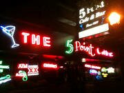
Belltown NIMBYs Have a Problem With This Upstart "5 Point" Place
- From the Publisher's Couch: The SunBreak's Progress, Chapter Two
- Watch This Space! Live from New York, It's Spectrum Dance Theater
- The Weekend Wrap: Neighborhood Headline News Feb. 20 - 26
- "The New New News" Illustrates Hybrid Vigor of News-Theatre


Most Recent Comments